


|
||

|

|
|

|
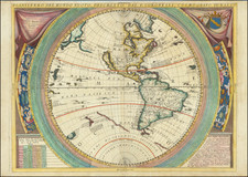
The Americas with the Sea of the West and the Latest Russian Discoveries
Striking example of the 1760 edition of Guillaume Danet's decorative map of America. It features the conjectural Sea of the West, and a large inset shows the Russian discoveries and various theories for an inland Northwest Passage.
Published by Louis Charles Desnos in Paris, the map provides a detailed historical overview of the exploration of America, beginning with Columbus, in a block of text in the lower left. The text also references the explorations of Amerigo Vespucci, Pedro Cabral, Thomas Auber, Ponce de Leon, Hernán Cortez, Ferdinand Magellan, John Sebastian Cabot, Juan Verazzano, Jacques Cartier, Francisco Pizzaro, Olivier de Noort, Willem Schouten, Jacques Le Maire, Father Marquette, Father Joliet, and De La Salle.
The portraits of these explorers run along the upper and lower borders of the decorative frame of the map. They are augmented with medallions holding the coat of arms of various provinces and colonies across the two continents. At left and right are pictorial representations of constellations.
A fine, large cartouche fills the upper left corner. Two angels guard the French coat of arms, while below Hermes, the herald, and a Native American sit surrounded by bales of goods and a telescope (Hermes), and an alligator and a bow and arrows (Native American).
Geographically, the primary feature of interest on the map is the massive Mer de L'Ouest (Sea of the West), which dominates the northwest part of America. The sea includes a wide open and optimistic watercourse from the Sea of the West to Hudson's Bay, labeled "Communication presumée" (presumed connection).
The sea is fed by inlets discovered, supposedly, by Martin de Aguilar and Juan de Fuca. The former navigator was a Spanish captain who sailed with Sebastian Vizcaino on a reconnaissance expedition up the California coast in 1602-3. Aguilar, commanding the Tres Reyes, was blown off course, to the north. When the seas calmed, Aguilar reported that he had found the mouth of a large river. Eighteenth-century geographers, including De L’Isle and Bauche, conjectured that the river was the entrance to the Sea of the West, as it is positioned on this map.
There is another entrance to the sea, this one labeled as the discovery of Juan de la Fuca. The authors are referring to Juan de la Fuca, the Castilianized name of Greek navigator Ioánnis Fokás (Phokás). Little archival evidence survives of Fuca’s career, but a chance meeting with an English financier, Michael Lok, in Venice in 1596 gave birth to rumors of Fuca’s voyages in the Pacific. Fuca reported that he had been sent north from New Spain twice in 1592 in search of the Strait of Anian. The Spanish Crown failed to reward Fuca’s discovery of an opening in the coast at roughly 47° N latitude and Fuca left the Spanish service embittered. His story lived on in Lok’s letters and eventually was published in Samuel Purchas’ travel collection of 1625. On many eighteenth-century maps, including this one, Fuca’s Strait is linked with a River or Sea of the West. In 1787, the present-day Juan de Fuca Strait was named by the wife of naval explorer Charles William Barkley, making permanent a label that had previously just been hopeful conjecture.
On the banks of the Sea of the West is Quivira, which refers to the Seven Cities of Gold sought by the Spanish explorer Francisco Vasquez de Coronado in 1541. In 1539, Coronado wandered over what today is Arizona and New Mexico, eventually heading to what is now Kansas to find the supposedly rich city of Quivira. Although he never found the cities or the gold, the name stuck on maps of southwest North America, wandering from east to west.
In the lower right is an inset showing the Pacific Northwest, including Alaska, as derived from the work of Joseph Nicolas De L’Isle. In a series of maps from the early 1750s, De L’Isle and Philippe Buache hypothesized as to the extent and source of a Sea of the West; this work is an important source bank for this map.
Joseph Nicholas De L'Isle spent much of his career in Russia, where he helped to found the Russian Academy of Sciences. While there, he had access to the latest findings of Russian explorers and was at the center of Russia’s geographic establishment; for example, he helped produce the first Russian atlas, the Atlas Russicus, with Ivan Kyrilov. He returned to Paris in 1747 with a large map collection, an event that drew some criticism from Russian academicians who thought he absconded with delicate materials.
The map identifies Russian discoveries from the previous several decades. Two expeditions led by Vitus Behring (1728-30, 1733-43) explored Kamchatka and what is now Alaska, charting the strait between them. De L’Isle interviewed Bering and used his charts from the voyages.
The map also includes the track of “Mrs Thiricou et de l’Isle de la Croyere” in June and July of 1741. De L’Isle’s half-brother, Louis De L’Isle de la Croyere, sailed with Captain Alexsei Chirikov (Tchirikov) to discover the fictional De Gama’s Land, or Companies Land. Joseph Nicholas was convinced that the island existed and provided his half-brother with maps to support the hypothesis. de la Croyere perished on the voyage, but his brother received his papers and published his findings on the map.
A major feature of the inset are the lakes and passages towards the east, including L. de Fonte. Admiral de Fonte supposedly sailed to the area in the mid-seventeenth century. The first mention of Fonte appears in two letters published in London in 1708 in two issues of The Monthly Miscellany or Memoirs for the Curious. The Fonte letters had been reprinted by Arthur Dobbs in his 1744 An Account of the Countries adjoining Hudson’s Bay and were mentioned in other travel accounts. Delisle’s copy of the letters came from Lord Forbes, British ambassador to Russia, as he explained in a memoir, Nouvelles Cartes des Decouvertes de l’Amiral de Fonte (Paris, 1753). He also read of them in Henry Ellis’ account of the 1746-7 expedition to Wager Inlet.
The letters recounted that Fonte had found an inlet near 53°N which led to a series of lakes. While sailing north east, Fonte eventually met with a Boston merchant ship, commanded by a Captain Shapley. One of Fonte’s captains, separated from the Admiral, reported he had found no strait between the Pacific and the Davis Straits, yet had reached 79°N, helped by local indigenous peoples. This story, with its suggestion of water passages connecting the Pacific Northwest with the east, inspired hope in some and doubt in others in the mid-eighteenth century. A few, like Irish mapmaker John Green, thought the entire story a farce. Many, including De L’Isle, Buache, Danet, and Desnos, thought the information conformed neatly to other recent discoveries and included Fonte on their map.
The map was first issued by Danet in 1731 and then later revised by Desnos, at which time he significantly reworked the cartographic details. This early Desnos edition of the map is quite rare, with only one example of a 1766 edition noted in AMPR between 1983 and 2011 (Librairie Le Bail-Weissert: 2003, Item 370 -- $5,700 USD) and a 1768 edition offered by Richard Arkway in 1990 (Catalogue XXXVI--$2,000).
The 1760 is the earliest of the Desnos editions, with the Sea of the West inset, that we have seen.
Many European maps of North America in the eighteenth century depict a large, western inland sea, hundreds of miles in diameter, with a small inlet to the Pacific and even some interior islands. The origins of this myth can be traced to several different sources and are tied to the search for a Northwest Passage. Like many cartographic myths, the Sea of the West persisted for decades, even in the face of strong evidence pointing to its non-existence.
One of the first European navigators to supposedly explore this area was Martin Aguilar. A Spanish captain, he sailed with Sebastian Vizcaino on a reconnaissance expedition up the California coast in 1602-3. Aguilar, commanding the Tres Reyes, was blown off course, to the north. When the seas calmed, Aguilar reported that he had found the mouth of a large river. Eighteenth-century geographers later conjectured that the river was the entrance to the Sea of the West.
Other maps placed the entrance to the Sea of the West via the Juan de Fuca Strait. Juan de la Fuca is the Castilianized name of Greek navigator Ioánnis Fokás (Phokás). Little archival evidence survives of Fuca’s career, but a chance meeting with an English financier, Michael Lok, in Venice in 1596 gave birth to rumors of Fuca’s voyages in the Pacific. Fuca reported that he had been sent north from New Spain twice in 1592 in search of the Strait of Anian. The Spanish Crown failed to reward Fuca’s discovery of an opening in the coast at roughly 47° N latitude and Fuca left the Spanish service embittered. His story lived on in Lok’s letters and eventually was published in Samuel Purchas’ travel collection of 1625. On many eighteenth-century maps, Fuca’s Strait is linked with a River or Sea of the West. In 1787, the present-day Juan de Fuca Strait was named by the wife of naval explorer Charles William Barkley, making permanent a label that had previously just been hopeful guesswork.
The source of the modern (18th Century) myth of the Sea or Bay of the West (Baye ou Mer de L'Ouest in French), are manuscript maps by Guillaume De L'Isle, who served as the Royal Geographer to the King of France at the end of the 17th Century and beginning of the 18th Century and is widely regarded as the most important map maker of his time. There is a map in Yale's map collection, which depicts a 16th Century Thames school map of North America with a large, "Branch of the South Sea," which closely resembles De L'Isle's Mer de L'Ouest, and may well be the source of De L'Isle's idea.
At the end of the 17th Century, Guillaume De L'Isle had access to the best available maps of the interior of North America, which were being provided from a number of missionary sources, as the French Missionaries pushed west of the Great Lakes and the Mississippi River and obtained information from the indigenous Indian tribes. De L'Isle was regularly producing and updating his manuscript maps in an attempt to integrate new and often conflicting information and improve upon the existing maps of North America. Many of his maps can be viewed as drafts, which were discarded in favor of other and considerably different models.
There are several De L'Isle manuscripts in the Bibliotheque Nationale de France, prepared as early as 1696 (dated), that depict this cartographic myth. Interestingly, while De L'Isle was a prolific publisher of printed maps, he never depicted the Sea or Bay of the West on any of his printed maps, which strongly suggests that he was not able to reconcile this information with the best available source information from America. During this same period, Jean Baptiste Nolin, who had in the prior decade collaborated with Vincenzo Maria Coronelli on his monumental globe for Louis XIV and produced a series of highly important maps of North America and its regions, would have also had access to many of the same reports and maps as De L'Isle. Nolin apparently gave greater credence to the concept than De L'Isle.
The earliest printed map to show the Bay of the West is Jean Baptiste Nolin's rare wall map of the world, published in about 1700. Nolin plagiarized the idea from Guillaume De L'Isle, as he testified when suing Nolin for plagiarism. He said, the Sea of the West “was one of my discoveries. But since it is not always appropriate to publish what one knows or what one thinks one knows, I have not had this sea engraved on the works that I made public, not wanting foreigners to profit from this discovery” (as quoted in Pedley, The Commerce of Cartography, 109). The court sided with De L'Isle and issued an order requiring Nolin to destroy the copper plates for the map (see Shirley 605). Nolin's map was in turn copied by the Mortier family, who issued 3 world maps shortly thereafter, showing Nolin's version of the Sea of the West, but the myth ignored for nearly half a century.
While the myth of the Sea or Bay of the West temporarily languished, the proliferation of Russian exploration off the Northwest Coast of America after 1740, as reported by Guillaume's younger brother Joseph Nicholas De L'Isle, reinvigorated interest in the region and forced the most prominent map makers of the period to re-examine existing knowledge. Joseph Nicolas served as a geographer to the Russian Academy and returned with this information to Paris. The re-introduction of the sea in the mid-eighteenth century was the result of Guillaume De L’Isle’s son-in-law, Philippe Buache’s review of his father-in-law’s papers. Although Guilluame De L’Isle never published a printed map showing the sea, he had postulated that it could exist, and that it might connect to a Northwest Passage through New France, not through English territory farther north.
The sea was a major part of Buache and Joseph-Nicholas Delisle’s maps of the North Pacific, published in the 1750s. While controversial, the features of those maps were quickly copied by other mapmakers, including the Sea of the West. The inland body of water lingered on maps until the later-eighteenth century.
During a period between 1750 and 1770, the most prominent French and British map makers advanced multiple and widely varying theories on the Northwest Coast of America. Denis Diderot dedicates several of the 10 maps in his monumental Encylopedie (1779 and after), to a comprehensive survey of the maps proffered by Joseph Nicholas De L'Isle (Guillaume's brother), Philippe Buache, Thomas Jefferys and others. The debate ended with Captain James Cook's and later George Vancouver and Comte Jean de la Perouse's explorations in the late 18th Century.
![[New General Map of North and South America Showing the Routes of Kruzenshtern and Lisyansky] НОВАЯ ГЕНЕРАЛЬНАЯ КАРТА СѢВЕРНОЙ И ЮЖНОЙ АМЕРИКИ СЪ ПОКАЗАНІЕМЪ ПУТЕЙ КРУЗЕНШТЕРНА И ЛИСЯНСКАГО](https://storage.googleapis.com/raremaps/img/small/58490.jpg)

![[Portrait] L'Amerique.](https://storage.googleapis.com/raremaps/img/small/79745.jpg)