


|
||

|

|
|

|
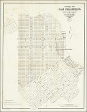
Important early map of San Francisco, the earliest obtainable map of the City.
The map shows three small sections in outline color, corresponding to the grants to Senora Briones, the claim of the heirs of Col. J.A. King, and the claim of Senor Pana under a Mexican grant. The streets, original lot numbers, government reserve, Yerba Buena Cemetery, and the earliest wharfs are shown, along with Portsmouth Square and Montgomery Fort.
The Eddy Map of San Francisco is the earliest known surviving map of the city published from accurate surveys, improving and expanding upon the prior work of O'Farrell.
William Eddy, surveyor for the town of San Francisco, created this first street map of the city in 1849. Only three years prior to the publication of the map, the United States had taken possession of that portion of California including San Francisco, and the next year, in 1847, an ordinance changed the city's name from Yerba Buena to San Francisco. Eddy’s mission was to resurvey the original 1847 plan laid out by Jasper O’Farrell (which was filed but never published), and to do so in a way that met both the demands of the expanding population as well as the need to replenish city coffers. Eddy carried out his work in the summer and fall of 1849 and filed the resulting official map on February 1, 1850, in Oregon City, Oregon, the site of the nearest Federal District Court. Interestingly, this original manuscript map (with no copies), still held in Oregon, did not include Yerba Buena Cemetery, which was staked out the next month, in March of 1850; the need for a city cemetery did not occur to city officials until the map was already on its way to Oregon.
Eddy’s map carries the publishing location of Washington, D.C. in the title but was certainly printed in San Francisco as well, as attested by a notice in the March 11, 1850 Daily Alta California newspaper advertising lithographic copies of the official map.
Eddy's map extends the city limits to Larkin, Eighth, and Townsend streets. The next year, California became a state.
This a wonderful early document of Gold Rush California.
![[Berkeley] This Is The Map of Berkeley Town Its Streets Go Winding Up & Down An Oak-Covered Campus It Wears For A Crown With People & Places of Renown](https://storage.googleapis.com/raremaps/img/small/97201.jpg)