|
||

|

|
|

|
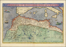
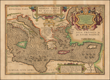
Rare and important Lafreri-school nautical chart of Europe, including the Mediterranean and Black Seas.
Bifolco & Ronca (2018, tav. 236) say of the map:
This nautical chart edited by Antonio Lafreri is presented as the "revista et emendata" version of Diego Homen's compilation, engraved by Paolo Forlani, examined on the previous page. Published just three years after the Venetian edition, it differs from it for the different territorial extension to the west, where this Roman version is cut off, and the Canary Islands are not represented. It seems certain that Lafreri had with him the map published by his nephew Claudio Duchetti and that he therefore had a copy made to be included in his cartographic catalog. Moreover, he could not face the accusation of plagiarism, as the Forlani map was not protected by any privilege. Compared to the previous one, this map appears to be much rarer. A second draft of the plate, modified in the title and in the cartouche, is edited by the French Philippe Thomassin in 1606. The matrix is present in the inventory of the printing house, drawn up posthumously in the house of the heir Girolama Piscina on April 10, 1627. The only example known of this edition is kept at the University Library of Utrecht. The plate had a subsequent edition (1648) by Giacomo de Rossi who first Destombes and then Meurer mistakenly identify as the third edition of Forlani. A copy of the 1648 edition is kept in Paris. The work is described in the last catalog of the de Rossi typography, drawn up by Lorenzo Filippo in 1735 (p. 9, no. 5) as "Navigation of Europe with parts of Asia, and of Africa bordering on it, carved in burin in two real leaves ".
Antonio Lafreri (1512-1577) (also known as Antoine Lafréry and Antoine du Pérac Lafréry) was a French mapmaker, engraver, and publisher who worked in Italy. Lafreri was born in Franche-Comté and moved to Rome around 1540. Lafreri sold sheet maps but he also bound maps into books for his clients based on their interests and needs. These are the famous Lafreri atlases, important pre-cursors to the modern atlas. He also published well known works such as the Speculum Romanae Magnificentiae (ca. 1575), a collection of engraved views and images of Rome. Lafreri was well-connected to the cartographic networks of the time, collaborating with Giacomo Gastaldi, Battista Agnese, Antonio Salamanca, Donato Bertelli, Paolo Forlani, and others.
![[Ancient and Modern German Empires] Carte de la Germany et les Diferents Etats ou ses Peuples ont Porte Leurs Conquestes](https://storage.googleapis.com/raremaps/img/small/78195.jpg)
![(First World War - Seriocomic) Европа въ 1915 г. [Europe in 1915]](https://storage.googleapis.com/raremaps/img/small/98679.jpg)
![[ First World War) ] The World Cannot Live Half Slave, Half Free -- The Prussian Blot -- 100,000,000 People Already Enslaved By Germany](https://storage.googleapis.com/raremaps/img/small/68731.jpg)