


|
||

|

|
|

|
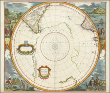
Scarce Late State.
Nice example of the Valk and Schenk edition of Jansson's second map of the North Polar regions, with several wonderful cartouches.
A fine decorative map of the North Polar regions, including Arctic North America, Scandinavia, and northern Asia. The information for this map is based on the discoveries of James, Barentsz, Baffin, Frobisher, Hall, Davis, and others and is very similar in appearance to Blaeu's map.
The map incorporates the discoveries of James along the southern and western shore of Hudson's Bay in 1631-32 and promotes the view that the famous "Northwest Passage" across northern North America did not exist. The map's detail would suggest the existence of a Northeast Passage as the coastline appears intact and the sea clear and without any barrier to progress. The Canadian Arctic waters, however, appear almost landlocked lacking any promise of a northwest route to the Indies.
This late edition of the map makes important changes to the cartography of the Arctic. For instance, Nova Zemlaya is substantially modified, with a strange isthmus connecting it to the Russian mainland. Spitsbergen is more fully formed, as well.
Jan Janssonius (also known as Johann or Jan Jansson or Janszoon) (1588-1664) was a renowned geographer and publisher of the seventeenth century, when the Dutch dominated map publishing in Europe. Born in Arnhem, Jan was first exposed to the trade via his father, who was also a bookseller and publisher. In 1612, Jan married the daughter of Jodocus Hondius, who was also a prominent mapmaker and seller. Jonssonius’ first maps date from 1616.
In the 1630s, Janssonius worked with his brother-in-law, Henricus Hondius. Their most successful venture was to reissue the Mercator-Hondius atlas. Jodocus Hondius had acquired the plates to the Mercator atlas, first published in 1595, and added 36 additional maps. After Hondius died in 1612, Henricus took over publication; Janssonius joined the venture in 1633. Eventually, the atlas was renamed the Atlas Novus and then the Atlas Major, by which time it had expanded to eleven volumes. Janssonius is also well known for his volume of English county maps, published in 1646.
Janssonius died in Amsterdam in 1664. His son-in-law, Johannes van Waesbergen, took over his business. Eventually, many of Janssonius’ plates were sold to Gerard Valck and Pieter Schenk, who added their names and continued to reissue the maps.
![[ Scandinavia ] Tabula Geographica Regnorum Sueciae Daniae et Norwegiae](https://storage.googleapis.com/raremaps/img/small/102797.jpg)