|
||

|

|
|

|
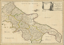
The First Cartographic Depiction of a Contemporary Major Volcanic Event
Rare early map of the Bay of Naples and environs, showing the contemporary eruption of the Phlegraean Fields in September of 1538. This is also the first printed map to focus in as much detail on the city of Naples; the first true map of the city would not be published until twenty-two years later.
This map is extremely narrow in its focus, it covers the two northern harbors in the Gulf of Naples, effectively stretching from just north of Pompeii to the Cape Miseno west of the city. Detail on the map is stunning, being a striking example of the early Lafreri-school design. The map is covered with decorative portrayals of ships, mountains, and more, to say nothing of the magnificently depicted Campi Flegrei volcano in full eruption. Vesuvius, just outside of the city, is shown as a towering mountain with sharp and steep sides.
The depiction of the Monte Nuovo eruption of 1538 is remarkable as a piece of 16th-century ephemera. The map seeks to capture a fleeting moment, which it does successfully: images of this eruption would persist in maps of the area for nearly a century.
Monte Nuovo Volcano
The last and only known historical eruption of the Campi Flegrei (Phlegraean Fields) caldera occurred in 1538. Following a rapid period of uplift following a long period of subsidence and a series of foreshock earthquakes, the volcano erupted on September 29th, ejecting pumice and smoke. The volcanic style changed rapidly over the early period of the eruption, as water infiltration changed the reaction dynamics of the magma.
The eruption lasted for over a week, with a sudden explosion on October 6th killing 24 visitors. Ash flow affected regions as far as Apulia and Calabria, with large fragments landing all over Naples.
This eruption was very important in the history of science because it was the first significant eruption to be documented by numerous witnesses, which have allowed modern researchers to accurately ascertain the eruptive style and nature of the event. This map represents an early effort to document the event, showing the city of Trepergole which would subsequently be destroyed, and documenting the subsidence following the eruption which lead to the sinking of cities and bridges.
Authorship
Despite the name Vico appearing on the map, the plate is not attributed to him. Scholarship has disagreed on the true authorship, with Marcel Destombes assigning the typography Salamanca. Giovanni Bertoni disagrees, suggesting that this instead comes from the studio of Tommaso Barlacchi. The sculptor's signature G.A. appears in the lower left.
States
Bifolco and Ronca note two states:
- Without the editorial date.
- With the signature of Petri de Nobilibus ormis.
The second state appeared much later than the first (c. 1585), published after Petri de Nobilibus had acquired the plate from Lafreri, who himself acquired the plate from an unknown source.
Rarity
This map is rare on the market. The last example we note sold at Sotheby's over twenty years ago.
The Lafreri School is a commonly used name for a group of mapmakers, engravers, and publishers who worked in Rome and Venice from ca. 1544 to 1585. The makers, who were loosely connected via business partnerships and collaborations, created maps that were then bound into composite atlases; the maps would be chosen based on the buyer or compiler’s interests. As the maps were initially published as separate-sheets, the style and size of maps included under the umbrella of the “School” differed widely. These differences can also be seen in the surviving Lafreri atlases, which have maps bound in with varying formats including as folded maps, maps with wide, trimmed, or added margins, smaller maps, etc.
The most famous mapmakers of the School included Giacomo Gastaldi and Paolo Forlani, among others. The School’s namesake, Antonio Lafreri, was a map and printseller. His 1572 catalog of his stock, entitled Indice Delle Tavole Moderne Di Geografia Della Maggior Parte Del Mondo, has a similar title to many of the composite atlases and thus his name became associated with the entire output of the larger group.
Antonio Salamanca was a print seller and publisher based in Rome. While he was known by the surname Salamanca, his family name was actually Martinez; he hailed from Salamanca, Spain. His shop was in the Campo de’ Fiori and it served as a gathering place for those with antiquarian interests. Later in his career, he partnered with Antonio Lafreri, the era’ most prominent Italian map publisher. Salamanca’s stock was sold to Lafreri after the former’s death.

![[Ostia / Lazio / Rome] Der Statt Ostien und umbligender Landtschafft : gelegenheit und abcontrafactur](https://storage.googleapis.com/raremaps/img/small/75245.jpg)
![[ Naples and Mount Vesuvius ] Topografia Dell' Agro Napoletano con les sue adjacenze . . . Anno MDCCXCIII](https://storage.googleapis.com/raremaps/img/small/99343.jpg)