|
||

|

|
|

|
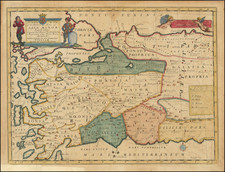
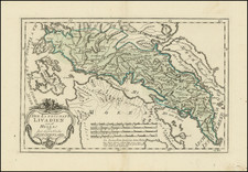
Very Rare Map Showing the Largest Naval Battle of the First Half of the Sixteenth Century -- And The Site of Octavius' Historic Battle with Antony and Cleopatra
Rare and vibrant map of the Gulf of Artha, showing the pivotal Battle of Preveza, engraved in Rome by Antonio Salamanca, which includes also historical references to the Battle of Actium, which pitted Octavius against Antony and Cleopatra.
Fought in 1538, the Battle of Preveza pitted the famed Ottoman commander and former pirate, Hayreddin Barbarossa, against a combined Holy League consisting of Spanish, Papal, Genoese, Venetian, and Maltese ships. led by Andrea Doria. The Ottoman victory cemented Ottoman supremacy in the Mediterranean until the Battle of Lepanto in 1571, and is generally considered the largest naval battle of the 16th century, until Lepanto in 1571.
The map shows the strategic geographic feature, which is on the western side of the Greek peninsula, just south of Corfu. The waters are shown in three ways. Shallow bays are marked with dashed parallel lines. Calm waters and deeper inlets have solid parallel lines. Deep, open waters are shown as rolling waves.
It is on these waves where the action of the battle took place. Galleys rowed by slaves maraud the waters, mounted with artillery in their bows. Both sides had such galleys, but they were the principal vessels of the Ottoman forces, giving them an advantage in maneuverability.
The sailing ships were chiefly under the command of the Holy League, making them dependent on the winds. This dependency came with a price, as seen here. The image shows crewmen frantically trying unfurl sails in one ship, while others are shown leaping from a burning vessel, its sails alight.
Although this was primarily a naval battle, there were some Ottoman troops stationed on land, as seen here with their camp behind Preveza. Other settlements nearby are reduced to smoking ruins.
Interestingly, there is a faint “37” printed in the waters near the ship in the top right corner. The meaning of this number is unknown. The rest of the script printed here was achieved using letter punches.
While the map is unsigned, experts confidently attribute the work to Salamanca.
Antony and Cleopatra in Actium
While the 1538 battle was certainly decisive, the cartouche in the upper left reminds the viewer of much older events. The gulf used to be known as the Gulf of Ambracio and it housed the city of Pyrrhus in the fourth century BCE. There was also another naval engagement that took place nearby, this one between Octavius and the legendary Antony and Cleopatra.
When Antony and Cleopatra joined forces in 41 BCE, the former’s relationship with Octavius, Julius Caesar’s chosen heir, grew strained. A decade later, Octavius declared war against Cleopatra. Their forces met in at the Battle of Actium, which is across the strait from Preveza. It is marked here with the temple of Apollo that stood in ancient Actium.
The superior forces of Octavius overwhelmed those of Antony and Cleopatra. The two separately broke through the enemy’s ranks and fled. This decisive defeat spelled doom for the couple. Within a year, Octavius attacked Alexandria. After the battle, which Antony lost, he was told that Cleopatra had died. Distraught, he stabbed himself, only to be told that she still lived. He lived long enough to tell her to make peace. She spoke with Octavius, but then committed suicide herself.
Barbarossa and the Battle of Preveza
The battle depicted here was no less monumental than that fought by Antony and Cleopatra fifteen hundred years earlier. Its protagonists included the most notorious pirate and naval commander of the Ottoman Empire, Hayreddin Barbarossa. The son of a successful potter and merchant from Lesbos, Khiḍr, as he was named, and his brothers initially took to sea to trade legitimately. However, as tensions rose between Christian and Ottoman forces, especially in North Africa, the brothers became privateers under the command of Korkud, a son of the Ottoman sultan Bayezid II.
Eager to avoid the politics of regime change in the Ottoman empire, the brothers settled in North Africa and raided from there. In 1516, they took Algiers. This victory drew Ottoman attention and the brothers increasingly worked alongside and within the operations of the empire. Khiḍr became known as Barbarossa, or Red Beard, and was named governor of Rhodes in 1522. He also took Tunis in 1531.
After scattering a Christian force under Genoese Admiral Andrea Doria, Khiḍr was granted the title of Hayreddin, or best of the faith. Soon thereafter, Pope Paul III assembled a Holy League to take on Barbarossa. Ironically, Doria was placed at the head of a combined 112 galleys, 50 galleons, 140 barques, and 60,000 soldiers. Barbarossa, sailing to meet him, had 122 galleys and galliots with 12,000 soldiers—he was outnumbered three ships to one.
After attempts to dislodge the Ottomans from their strongholds at Preveza and Actium, Doria drew his fleet away. Barbarossa approached the back of the overextended Holy League ships at dawn of September 27, 1538, throwing them into disarray. He attacked the Venetians and Maltese, who thought Doria was coming to support them. Left adrift with no wind, the ships fought. The Ottomans had swifter, more agile vessels, but the Venetians had a massive flagship that could fire double broadsides.
Doria attempted to draw Barbarossa out to sea, but the Ottoman commander was too clever to abandon the shelter of the coast. On the morning of the 28th, Doria sailed for Corfu, where the Venetian flagship had limped, abandoning the battle. Barbarossa had won. His ships sank ten Holy League vessels, burned three, and captured 3,000 prisoners. Comparably, he lost no ships, although some were damaged, with 400 dead and 800 wounded. The battle established Ottoman naval supremacy for the next three decades.
Rarity
This map is quite rare on the market. This is only the first time we have offered it in over twenty-five years of trading.
The Lafreri School is a commonly used name for a group of mapmakers, engravers, and publishers who worked in Rome and Venice from ca. 1544 to 1585. The makers, who were loosely connected via business partnerships and collaborations, created maps that were then bound into composite atlases; the maps would be chosen based on the buyer or compiler’s interests. As the maps were initially published as separate-sheets, the style and size of maps included under the umbrella of the “School” differed widely. These differences can also be seen in the surviving Lafreri atlases, which have maps bound in with varying formats including as folded maps, maps with wide, trimmed, or added margins, smaller maps, etc.
The most famous mapmakers of the School included Giacomo Gastaldi and Paolo Forlani, among others. The School’s namesake, Antonio Lafreri, was a map and printseller. His 1572 catalog of his stock, entitled Indice Delle Tavole Moderne Di Geografia Della Maggior Parte Del Mondo, has a similar title to many of the composite atlases and thus his name became associated with the entire output of the larger group.
Antonio Salamanca was a print seller and publisher based in Rome. While he was known by the surname Salamanca, his family name was actually Martinez; he hailed from Salamanca, Spain. His shop was in the Campo de’ Fiori and it served as a gathering place for those with antiquarian interests. Later in his career, he partnered with Antonio Lafreri, the era’ most prominent Italian map publisher. Salamanca’s stock was sold to Lafreri after the former’s death.