|
||

|

|
|

|
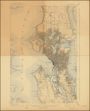
Early water distribution and land promotion map for land adjacent to the Columbia River in the vicinity of Hanford, Washington.
The land depicted on the map stretches from Savage Island to a site now called Audrey, Washington. The area is of course most famous for hosting the Hanford Site, which was a major nuclear production facility in the early stages of the U.S. atomic weapons and power projects.
A note explains the location, climate, soil, water, electricity, and electric railway and steamboat service for the area.
The Town of Hanford
The Hanford History Project provides the following description of the early existence and eventual demise of the town of Hanford:
The name Hanford is forever tied to the Manhattan Project and construction of the first atomic weaponry, but few traces remain of the town upon whose ruins the nuclear age was born. Although the town of Hanford was less than 40 years old when government bulldozers leveled its buildings to construct plutonium production facilities in the early 1940s, its residents had already built a resilient community and agricultural economy. Irrigation water was the lifeblood for many farming communities and Hanford owed its existence to large-scale irrigation projects. Entrepreneur Manley Bostwick Haynes and his father-in-law Judge Cornelius Hanford led these efforts, founding the Priest Rapids Irrigation & Power Company (PRIPC) in 1905 to irrigate 32,000 acres in the Priest Rapids Valley. These development efforts depended upon the successful establishment of a company town in the region, a seed Hanford and Haynes hoped would blossom into an economic powerhouse.
Early disagreements over the best location for a town contributed to the dissolution of the PRIPC. Some investors, including Hanford and Haynes, established the Hanford Irrigation & Power Company (HIPC) while others formed the White Bluffs Irrigation Company (WBIC).
Atomic Heritage Foundation has a short video about irrigation in the Priest Rapids Valley: www.atomicheritage.org/tour-stop/importance-irrigation#.YMO9BvlKjAQ
Rarity
OCLC records one example of the map, though it is itself an "Internet Resource", tied to Washington State Historical Society. Despite this ambiguity, it would make sense that Washington Historical has the map itself.
![(Canadian-American Boundary) [Group of 11 photographs by Alexander Gardner, including 3 after the British Commission's 1860-61 photographs, for the North American Boundary Commission Survey along the 49th Parallel, used in settling Hudson's Bay Co. claims in the British and American Joint Commission]](https://storage.googleapis.com/raremaps/img/small/95481.jpg)
![[ North Fork Snoqualmie River -- Calligan Lake ] Township No. 25 North, Range No. 9 East.](https://storage.googleapis.com/raremaps/img/small/101663.jpg)