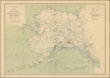
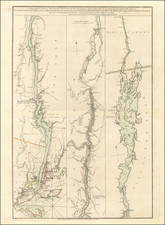
![[ Cook's Discoveries in Russian America ] Chart of the NW Coast of America and the NE Coast of Asia explored in the Years 1778 & 1779 . . . By James Cook](https://storage.googleapis.com/raremaps/img/small/68831.jpg)


|
||

|

|
|

|
Striking Map of the North Pacific From Cook’s Third Voyage Account
Fine example of the map of the Northern Pacific and contiguous coasts of America and Asia, from the official account of Captain James Cook’s third voyage, published in London in 1784.
The map, on a curved projection, centers on the Bering Strait, showing how close Asia and North America are at high latitudes. Kamchatka is to the east, with a remarkable outline of Alaska to the west. The North American coast continues to the southeast, but the interior of North America is left empty.
For the first time on a printed map the coastline of Alaska and the northwest coast of North America are accurately portrayed. The map displays Cook and his crew’s great contribution to the mapping of the area, particularly along the coast of what is today Alaska (especially near Prince William Sound), in the Aleutians, and in the Bering Strait.
Cook's route in 1778, and Clerke’s route in 1779, after Cook’s death in Hawai’i, are shown in detail. As noted in the map's legend below the title, the map is also drawn in part from a Russian manuscript map. The Russians had explored the area during the Kamchatka Expeditions led by Vitus Bering (1725-30, 1733-43), and continued to sail along the northeast coast of Asia.
Cook’s third voyage
After two Pacific cruises that observed the Transit of Venus, charted New Zealand, the eastern coast of Australia, and many islands; and disproved the existence of a vast southern continent, Cook’s third voyage focused on searching for the Northwest Passage. It was also tasked with the return of Mai, a Ra’iatean man and the first Polynesian visitor to Britain, who had joined Cook’s second voyage.
Cook in the Resolution was joined by Charles Clerke in the Discovery. Resolution sailed in July from Plymouth, rounded the Cape of Good Hope, visited the Kerguelen group in the Southern Indian Ocean, then called at Tasmania before heading to New Zealand.
In the spring of 1777, the ships sailed north, first to Tonga, and then to Tahiti. They left Mai on Huahine, in a wooden house built for him by the crew. Cook continued north, and became the first European to encounter the Hawaiian Islands, in January 1778.
During the warm months (in the northern hemisphere) of 1778, Cook and his crew charted the northwestern coast of North America, calling at Nootka Sound and Prince William Sound. They went up the Cook Inlet, which they thought could be a Northwest Passage, but it proved to be a false start. Heading west, they skirted the Aleutians and sighted the Asian coast. In January 1779, they returned to Hawai’i to resupply and rest.
In Kealakekua Bay, Cook was greeted warmly by the Hawaiians. They stayed for three weeks, enjoying the considerable hospitality of the people. In early February, the ships set out for another northern tour, but only a few days from Hawai’i the Resolution’s mast was damaged, forcing their return.
This time, they were not welcomed by crowds. During a dispute over a stolen boat, a scuffle broke out. When it was over, sixteen Hawaiians, four marines, and Cook were dead.
Clerke took command. He forced the Hawaiians to give him Cook’s remains, which were buried at sea. He then led the ships north, passing through the Bering Strait before turning back due to ice. In August of 1779, Clerke too died, of consumption, while near Kamchatka. A third commander, John Gore, then had to lead the ships home.
The ships sighted Japan on their southward journey before calling at Macao. There, they made sizeable profits by selling sea otter pelts, kickstarting a new industry. By April 1780, the Resolution and Discovery were back at the Cape of Good Hope. They returned to Britain via the Orkneys, anchoring in the Thames on October 7, 1780.
A controversial publication history
This chart is of tremendous importance, providing a highly important advance in the mapping of the coastlines depicted here. It is also a map of great controversy, having been the subject of an internal struggle among the editors of Cook's official account of his third voyage and those who actually accompanied Cook on his final voyage and were present at the time the observations were taken.
This chart was one of two competing charts; this one appeared in the official account of the voyage, the other was suppressed and then published separately by William Faden, also in 1784. Both charts had been prepared by Cook's primary cartographic assistant on his third voyage, Lieutenant Henry Roberts. Roberts served as the Master’s Mate on the HMS Resolution. However, because of disputes among the editors, Roberts ceased work on the chart, leaving T. Harmar to finish the plate.
Roberts worked with James King, another officer on the voyage, to prepare the charts and other materials for publication. Upon the return of the Resolution and Discovery, a team of prominent individuals, including Dr. John Douglas, editor, Alexander Dalrymple, Cook's longtime rival, Sir Joseph Banks, and Lord Keppel, became involved. The production process was highly contentious. As noted by Hellen Wallis:
The maps and engravings were a major source of disagreement between the editors and the committee whose proceedings seem to have become more arbitrary with the succession of Keppel as First Lord. Banks and Webber [the voyage artist] supervised the engraving of the drawings while Alexander Dalrymple (none other) "at Lord Sandwich's desire," had direction of the charts and coastal views, with the exception of the general chart. Under the sole direction of the Admiralty this was being prepared by Lieutenant Henry Roberts, who had served as master's mate in the Resolution under William Bligh.
Roberts objected to suggested changes to the general chart of the voyage by Dalrymple, including the omission of Samuel Hearn’s findings in the interior of North America, from his important overland expedition of 1770-1772. His chart was replaced by this one.