This item has been sold, but you can enter your email address to be notified if another example becomes available.


|
||

|

|
|

|
Stock# 73859
Description
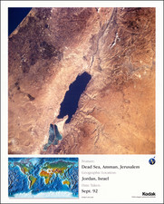
Interesting photographic poster of satellite imagery of the Holy Land around the Dead Sea, taken by NASA in October 1984.
The image encompasses parts of Israel, Syria, Lebanon, and Jordan.
The map comes from a series of posters that were apparently prepared by Kodak for internal use to demonstrate how their technology could be used with the budding field of satellite imagery.
![Paradise or the Garden of Eden With the Countries circumjacent Inhabited by the Patriarchs [shows Cyprus]](https://storage.googleapis.com/raremaps/img/small/84459.jpg)
![[Beirut, Lebanon] The Port of Beirout in Syria](https://storage.googleapis.com/raremaps/img/small/76131.jpg)
![(Yom Kippur War Aftermath) Rozmieszczenie posterunkow w strefie buforowej [Placement of Outposts in the Buffer Zone] | Egypt 1:100,000 (Port Said, El-Tina Bay, Sabkhet El-Bardawil)](https://storage.googleapis.com/raremaps/img/small/96264.jpg)