|
||

|

|
|

|
Stock# 73849
Description
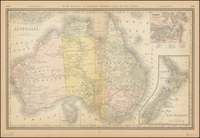
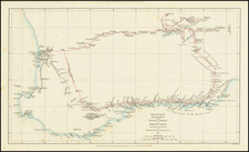
First Edition of this interesting regional map of Eastern Australia and New Zealand, published by Robert Wilkinson.
The map extends from the Solomon and Queen Charlotte Island in the North to New South Wales and New Zealand. Includes large insets of L. Howes and Norfolk areas and Port Jackson. An interesting and detailed coastal chart during the early era of discovery in these regions.
Robert Wilkinson was active in London as a cartographic publisher from 1785 to 1825. He produced a number of nice works, including a General Atlas and a re-issuance of Bowen & Kitchen's English Atlas, along with excellent large format separate maps.