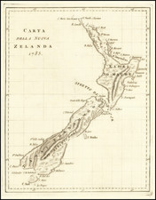
|
||

|

|
|

|
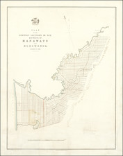
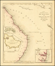
Scarce plan of the area around New Plymouth, New Zealand, produced by John Arrowsmith for the British Parliament during a turbulent time in the history of the Colony.
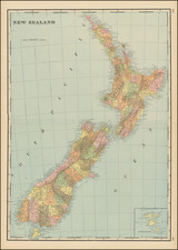
The map is oriented with northwest at the top. New Plymouth is a town on the west coast of New Zealand's North Island.
Land Disputes
The 1840s were a troubled time in New Zealand, as friction between white settlers and the Maori reached a boiling point. Wikipedia provides a detailed summary of the situation in New Plymouth in the early 1840s:
As settlers arrived, they occupied allotments throughout the coast to beyond Waitara. Many had bought land from the New Zealand Company before the company had purchased the land itself. Tensions between Maori and settlers soon became evident: a party of settlers were driven from land north of the Waitara River in July 1842 and surveyors were obstructed by a group of 100 Maori in 1843. Yet the town continued to thrive: by 1844 it had two flour mills on the Huatoki River and by 1847 it was recorded there were 841 hectares of land in cultivation.
In May 1844 William Spain, who had been appointed Land Claims Commissioner to examine New Zealand Company land claims, began inquiries in Taranaki. The company withdrew its two large land claims of 1840, restricting its claim of "legitimately purchased" land to Nga Motu. Spain ruled in its favour, endorsing its claim to 24,000 ha extending north from the Sugar Loaf Islands, except for pas, burial places and land in cultivation (48ha), native reserves of 10 per cent of the land (2400ha), land for the Wesleyan Mission Station (40ha), and land for Barrett and his family (72ha).
On 2 July Spain wrote to Governor Robert FitzRoy advocating the imposition of a military force to persuade the Maori that everything was in their best interests, or as he put it, to demonstrate "our power to enforce obedience to the laws, and of the utter hopelessness of any attempt on their part at resistance ..." As Spain saw it, New Zealand had been colonised for philanthropic reasons, "to benefit the Natives by teaching them the usefulness of habits of industry, and the advantages attendant upon civilisation."
The award, wrote J.S. Tullett in his history of the city, "was received with great hostility by the Maoris". They wrote letters of strong protest to FitzRoy, who responded with sympathy. After visiting New Plymouth in late 1844, FitzRoy formally set aside Spain's award, acknowledging that the land had been sold without the approval of the absentees. He substituted it for a 1400ha block that became known as the "Fitzroy block", which included the town site and only the immediate surrounding area. Many settlers who had taken up land outside the Fitzroy block were thus forced to move back within its boundaries, fostering widespread hostility towards FitzRoy.
According to the Waitangi Tribunal, the Fitzroy block deal was less a purchase than a "political settlement based on the reality that there were already settlers on the land, who had to be either accepted or driven out ... (the sale was) more akin to a treaty, because Maori also imposed two significant conditions. The first was that settlers still outside the Fitzroy block would be brought back into it and the second was that the settlers would expand no further." A 12-metre high boundary mark, known as the FitzRoy Pole, was later erected on the banks of the Waiwakaiho River to indicate the limit of Pākehā settlement.
The Arrowsmiths were a cartographic dynasty which operated from the late-eighteenth century to the mid-nineteenth. The family business was founded by Aaron Arrowsmith (1750-1823), who was renowned for carefully prepared and meticulously updated maps, globes, and charts. He created many maps that covered multiple sheets and which were massive in total size. His spare yet exacting style was recognized around the world and mapmakers from other countries, especially the young country of the United States, sought his maps and charts as exemplars for their own work.
Aaron Arrowsmith was born in County Durham in 1750. He came to London for work around 1770, where he found employment as a surveyor for the city’s mapmakers. By 1790, he had set up his own shop which specialized in general charts. Arrowsmith had five premises in his career, most of which were located on or near Soho Square, a neighborhood the led him to rub shoulders with the likes of Joseph Banks, the naturalist, and Matthew Flinders, the hydrographer.
Through his business ties and employment at the Hydrographic Office, Arrowsmith made other important relationships with Alexander Dalrymple, the Hudson’s Bay Company, and others entities. In 1810 he became Hydrographer to the Prince of Wales and, in 1820, Hydrographer to the King.
Aaron Arrowsmith died in 1823, whereby the business and title of Hydrographer to the King passed to his sons, Aaron and Samuel, and, later, his nephew, John. Aaron Jr. (1802-1854) was a founder member of the Royal Geographical Society (RGS) and left the family business in 1832; instead, he enrolled at Oxford to study to become a minister. Samuel (1805-1839) joined Aaron as a partner in the business and they traded together until Aaron left for the ministry. Samuel died at age 34 in 1839; his brother presided over his funeral. The remaining stock and copper plates were bought at auction by John Arrowsmith, their cousin.
John (1790-1873) operated his own independent business after his uncle, Aaron Arrowsmith Sr., died. After 1839, John moved into the Soho premises of his uncle and cousins. John enjoyed considerable recognition in the geography and exploration community. Like Aaron Jr., John was a founder member of the RGS and would serve as its unofficial cartographer for 43 years. Several geographical features in Australia and Canada are named after him. He carried the title Hydrographer to Queen Victoria. He died in 1873 and the majority of his stock was eventually bought by Edward Stanford, who co-founded Stanford’s map shop, which is still open in Covent Garden, London today.