|
||

|

|
|

|
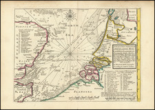
Attractive antique map of the east coast of England and the entrance to the Thames Estuary, published in Amsterdam at the end of the 17th century.
The shoals of the entrance to the Thames are well rendered.
This map was published a few decades after the famous Dutch "Raid on the Medway", through the area covered by the chart.
Alexis-Hubert Jaillot (ca. 1632-1712) was one of the most important French cartographers of the seventeenth century. Jaillot traveled to Paris with his brother, Simon, in 1657, hoping to take advantage of Louis XIV's call to the artists and scientists of France to settle and work in Paris. Originally a sculptor, he married the daughter of Nicholas Berey, Jeanne Berey, in 1664, and went into partnership with Nicholas Sanson's sons. Beginning in 1669, he re-engraved and often enlarged many of Sanson's maps, filling in the gap left by the destruction of the Blaeu's printing establishment in 1672.
Pierre, or Pieter, Mortier (1661-1711) was a Dutch engraver, son of a French refugee. He was born in Leiden. In 1690 he was granted a privilege to publish French maps in Dutch lands. In 1693 he released the first and accompanying volume of the Neptune Francois. The third followed in 1700. His son, Cornelis (1699-1783), would partner with Johannes Covens I, creating one of the most important map publishing companies of the eighteenth century.
![[ Chatham Harbor ] A Geometrical Plan & North West Elevation of his Majesty's Dock-Yard at Chatham, with ye village of Brompton adjacent.](https://storage.googleapis.com/raremaps/img/small/84698.jpg)