|
||

|

|
|

|
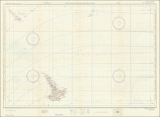
A Foundational New Zealand Map.
Very rare map of New Zealand, relating to the complicated land ownership and governance issues facing the islands in the 1840s.
The map was made by John Arrowsmith, heir to the great Arrowsmith firm, and one of the foremost British mapmakers of the 19th century. It was printed by Luke James Hansard, the official printer for the British Parliament.
The map is one of John Arrowsmith's very rare parliamentary report maps, which did not appear in his standard atlases.
This map was prepared for Correspondence Relative to a Grant of a Proprietary Government to the New Zealand Company.
The abstract to Rosemarie V. Tonk's 1986 thesis, "The first New Zealand land commissions, 1840-1845" summarizes the land ownership issues facing New Zealand at this time:
In early 1840 New Zealand was annexed to the Australian colony of New South Wales and William Hobson became Lieutenant-Governor of the new dependency. One of Hobson's first priorities was to sort out who owned what land in New Zealand. Thus a Commission was set up to investigate the land claims. The first New Zealand Land Commission was established under the New South Wales Act, 4 Victoria No. 7 (August 1840) and three Commissioners were appointed. They began examining claims early in the following year. Part One of this thesis deals with the origins of the Commission, the legislation which governed its activities and the work of the Commissioners - notably the difficulties which they encountered and what they actually achieved. A separate Commission was set up in Britain to deal with the claims of the New Zealand Company which held that it had bought some 20,000,000 acres of land centering on the Cook Strait in 1839 and to which it had already sent hundreds of settlers by the end of 1840. William Spain, appointed the Commissioner to investigate the Company's claims, began work early in 1842. The second part of this thesis is concerned with how his work progressed - particularly in the face of determined opposition from the Company's local officials - and how the Company gained a title to much of the land it claimed under an agreement made with the British Government in November 1840, in spite of Spain's finding that the company's 1839 purchases were hardly purchases at all.
The Arrowsmiths were a cartographic dynasty which operated from the late-eighteenth century to the mid-nineteenth. The family business was founded by Aaron Arrowsmith (1750-1823), who was renowned for carefully prepared and meticulously updated maps, globes, and charts. He created many maps that covered multiple sheets and which were massive in total size. His spare yet exacting style was recognized around the world and mapmakers from other countries, especially the young country of the United States, sought his maps and charts as exemplars for their own work.
Aaron Arrowsmith was born in County Durham in 1750. He came to London for work around 1770, where he found employment as a surveyor for the city’s mapmakers. By 1790, he had set up his own shop which specialized in general charts. Arrowsmith had five premises in his career, most of which were located on or near Soho Square, a neighborhood the led him to rub shoulders with the likes of Joseph Banks, the naturalist, and Matthew Flinders, the hydrographer.
Through his business ties and employment at the Hydrographic Office, Arrowsmith made other important relationships with Alexander Dalrymple, the Hudson’s Bay Company, and others entities. In 1810 he became Hydrographer to the Prince of Wales and, in 1820, Hydrographer to the King.
Aaron Arrowsmith died in 1823, whereby the business and title of Hydrographer to the King passed to his sons, Aaron and Samuel, and, later, his nephew, John. Aaron Jr. (1802-1854) was a founder member of the Royal Geographical Society (RGS) and left the family business in 1832; instead, he enrolled at Oxford to study to become a minister. Samuel (1805-1839) joined Aaron as a partner in the business and they traded together until Aaron left for the ministry. Samuel died at age 34 in 1839; his brother presided over his funeral. The remaining stock and copper plates were bought at auction by John Arrowsmith, their cousin.
John (1790-1873) operated his own independent business after his uncle, Aaron Arrowsmith Sr., died. After 1839, John moved into the Soho premises of his uncle and cousins. John enjoyed considerable recognition in the geography and exploration community. Like Aaron Jr., John was a founder member of the RGS and would serve as its unofficial cartographer for 43 years. Several geographical features in Australia and Canada are named after him. He carried the title Hydrographer to Queen Victoria. He died in 1873 and the majority of his stock was eventually bought by Edward Stanford, who co-founded Stanford’s map shop, which is still open in Covent Garden, London today.
![Neu-Seeland [with] West Australien [with] Tasmania](https://storage.googleapis.com/raremaps/img/small/98073.jpg)