|
||

|

|
|

|
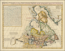
Scarce map extending from the Chesapeake to New England, St. Johns and Port Royal, and showing a signle Great Lake "Lake of Herekoys ou Lac des Iroquois."
While the map is in French, the nomenclature is nearly all in English.
Nice detail in the Chesapeake and around Long Island, including a very early use of the name New York and Manhattans Island. New Haven, Connecticut, New London, Fisher's Island, Pymoth, Boston, Marblehead, Salem, Cape An n, Cape Cod, York, and a handful of other early English placenames also appear, as does a very early appearance of Maryland on the map.
The map appeared in Henri Justel's Receuil De Divers Voyages Faits En Afrique Et En L'Amerique, published in Paris in 1674, which included a translation of Richard Blome's A DESCRIPTION OF THE ISLAND OF JAMAICA (1672), from which this map derives. The original Blome work is now virtually unobtainable.
Henri Justel (1620-93), a book collector and scholar, was a secretary of Louis XIV, fleeing France before the revocation of the Edict of Nantes. He settled in England, and was appointed Keeper of the King's Library at St. James Palace.