


|
||

|

|
|

|
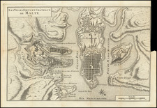
The Island of Malta—Lafreri School Rarity in Full Original Color
Fine, old-color example of this rare Italian map of Malta, based on the so-called Dillingen map of the island.
The map frames the main island of Malta, with Camino and a bit of Gozo to the west. There are many place names included, some of which can be connected to modern place names; for example “Bobakra” is Birkirkara, and “Dinagle” is Dingli. Galleys patrol the waters near the islands, a reference to the pirates that plagued the Mediterranean when the map was made. A text box in the upper left corner describes the extent and location of the island, which is at a strategic chokepoint separating the eastern and western Mediterranean.
The largest feature on the map is a large fortified city in the center. This is Mdina, the silent city, and the capital of the island from ancient times until 1530. It was formed in the eighth century BCE by the Phoenicians as Maleth; the Romans changed its name to Melite. The city was reduced to its present walled size during the Arab occupation during the Byzantine period; this is also when it became known as Mdina. In the northeast is another fortified promontory labeled “Castello.” This castle is the formidable Fort Saint Angelo, the oldest of the military strongholds protecting Malta’s Grand Harbour.
While there is no title on the first state of the map, Stefano Bifolco attributes the map to Camocio based upon the addition of the Camocio imprint on the second state, which is known in a single copy kept in the museum of the Cathedral of Mdina.
The so-called Dillingen map of the Maltese archipelago is an anonymous map, appearing without date or editorial information. The first state of the map is held in a single example in the Dillingen Library and has therefore been given the name Dillingen by Albert Ganado, the world’s foremost Malta map expert. Bifolco notes that the Dillingen map is actually a proof state, printed before the inscription in the title block seen here was added. Ganado states that it was an important prototype for other contemporary maps of Malta. Bifolco explains that the Dillingen map is based on Lafreri's map of 1551, from which it derives all of its placenames. Due to the presence or omission of some elements, for example the absence of Fort St. Elmo, Ganado suggests dating the map to around 1551, but Bifolco notes that it is more likely dated to just before 1558, when the scheme of the new fortress designed by the architect Bartolomeo Genga began to circulate in Europe.
The map shows Malta at a time of transition. Emperor Charles V, with the approval of Pope Clement VII, granted the Maltese archipelago to the Knights of St. John in 1530, after the Knights had lost Rhodes to the Ottomans in 1522. The Knights quickly moved to increase the fortifications of the island, as it too was under threat from an Ottoman invasion or siege. Indeed, the Ottomans tried to take Malta in 1551, when corsairs captured practically the entire population of the neighboring island of Gozo.
The Knights focused their efforts on Fort Saint Angelo, in the Grand Harbour, and made their capital in Birgu. They also built Fort Saint Elmo, on the same peninsula where Valletta is today, and Fort Saint Michael, at Senglea. The latter two would have been new when this map was made and they are not shown here.
In 1565, the Ottomans returned. The Knights lost Fort St. Elmo but held out across the Grand Harbrou to emerge victorious after three months. To mark the victory, the Knights set about building a new capital city; they named it for the Grand Master of the Knights of Malta, Jean de Valette. Thus, this map shows Malta at a pivotal moment, just before the Great Siege and the construction of Valletta.
States of the map
There are three known states:
- Pre-dates Camocio name in the title cartouche.
- Camocio name added in cartouche.
- Camocio name removed, but still visible.
Rarity
The map is rare on the market. We were unable to locate any examples on the market in the past thirty years; this is the first time we have held the map.
The Lafreri School is a commonly used name for a group of mapmakers, engravers, and publishers who worked in Rome and Venice from ca. 1544 to 1585. The makers, who were loosely connected via business partnerships and collaborations, created maps that were then bound into composite atlases; the maps would be chosen based on the buyer or compiler’s interests. As the maps were initially published as separate-sheets, the style and size of maps included under the umbrella of the “School” differed widely. These differences can also be seen in the surviving Lafreri atlases, which have maps bound in with varying formats including as folded maps, maps with wide, trimmed, or added margins, smaller maps, etc.
The most famous mapmakers of the School included Giacomo Gastaldi and Paolo Forlani, among others. The School’s namesake, Antonio Lafreri, was a map and printseller. His 1572 catalog of his stock, entitled Indice Delle Tavole Moderne Di Geografia Della Maggior Parte Del Mondo, has a similar title to many of the composite atlases and thus his name became associated with the entire output of the larger group.
![Malte [Malta | Valetta]](https://storage.googleapis.com/raremaps/img/small/79497.jpg)
![[Composite Lafreri-style Atlas of Battle Plans and Fortifications]](https://storage.googleapis.com/raremaps/img/small/92702.jpg)
![[Valletta] The Harbor of Valete in Malta](https://storage.googleapis.com/raremaps/img/small/71480.jpg)
![Valetta, the Capital of the Island of Malta [with] Balearic Islands [and] Corsica and Sardinia](https://storage.googleapis.com/raremaps/img/small/60552.jpg)
![[ Kingdom of Sicily, with Malta ] Carte De L'Isle Et Royaume De Sicile. Par Guillaume Delisle de l'Academie R. des Sciences. À Venise par P. Santini 1779.](https://storage.googleapis.com/raremaps/img/small/102161.jpg)