|
||

|

|
|

|
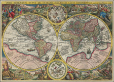
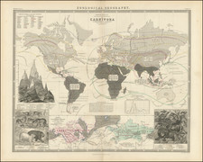
A superb example of George Washington Bacon's exuberant map of the world, which was published in London in the 1870s.
The map sheet is composed of a multitude of detailed sections; a kind of world clock; portraits of four famous explorers (Columbus, Cook, Raleigh, and Livingstone); coins from around the world; illustrations of peoples and races of the world with their ethnic garb; flags of the world; coats of arms of various nations; diagrams of rivers and mountains; a world map showing religions; and a general double-hemisphere world map.
Though the map reflects Victorian chauvinism, it is illustrative of the true diversity of the world at that time.
The lower-right corner includes a portrait of Dr. David Livingstone, of African exploration fame. Livingstone rose to the highest levels of national fame in the United Kingdom in 1874, and this, combined with the G.W. Bacon & Co. imprint, lead us to give it a circa date of '74.
The map appeared in at least two variants, with the most recognizable difference being the decorative framing of the ethnographic illustrations directly above and below the world map. The present edition lacks the borders around the illustrations.
The concept of merging a central map with additional decorative elements and calling the map "pictorial" probably arose with Humphrey Phelps in American in the 1830s and '40s.