|
||

|

|
|

|
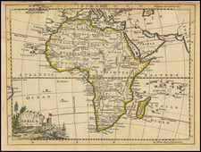
Rare 1646 State
Rare engraved map of Africa by Petrus Bertius presumed to have first been issued in Paris in 1624.
Betz (61.1) says that the first edition is "assumed to exist but location is not known" basing that on Tooley's description of the 1624 Bertius map of the Americas, which was surely issued along with maps of the other continents. Indeed, Burden (209) was also unable to locate a 1624 first state of the Americas map.
The Bertius map derives its cartography from the 1619 Jodocus Hondius Junior map of Africa and introduced that mapping to France. As such, it was widely copied in France from the 1620s through to the 1660s. Because of this, many French maps of Africa bear Bertius's name, even if they were first issued long after his death in 1629.
Betz 61.2 notes:
The second state is attributed to Michel van Lochom, as two of the four continent maps (not Africa nor America) bear Van Lochom's name. Van Lochom (1601-1647), born in Antwerp, was known as an engraver and printer in Paris. As Bertius died in 1629 and this state was not published until 1640, it is unclear if Van Lochom purchased the plates directly from Bertius or through some intermediary for his issue of the maps in 1640. The second state of the Africa map appears in some examples of Pierre D'Avity's Description Generale, published by Sonnius and Bechet in 1643.
Rarity
This is the first time we have ever had the 1646 state of the map.
Petrus Bertius was a Flemish historian, theologian, geographer, and cartographer. Known in Dutch as Peter de Bert, Bertius was born in Beveren. His father was a Protestant preacher and his family fled to London around 1568. The young Bertius only returned to the Low Countries in 1577, to attend the University of Leiden. A bright pupil, Bertius worked as a tutor and was named subregent of the Leiden Statencollege in 1593. He ascended to the position of regent in 1606, upon the death of the former regent, who was also Bertius’ father-in-law. However, due to his radical religious views, he eventually lost his teaching position and was forbidden from offering private lessons.
His brothers-in-law were Jodocus Hondius and Pieter van den Keere, who were both prominent cartographers. Bertius began his own cartographic publishing in 1600 when he released a Latin edition of Barent Langenes’ miniature atlas Caert Thresoor (1598). He published another miniature atlas that first appeared in 1616.
By 1618, Bertius was named cosmographer to Louis XIII. He converted to Catholicism and took up a position as professor of rhetoric at the Collège de Boncourt (University of Paris). In 1622, Louis XIII created a chart of mathematics specifically for Bertius and named him his royal historian. He died in Paris in 1629.
![[ First Modern Map of Southern Africa ] Tabula Moderna Secunde Porcionis Aphricae](https://storage.googleapis.com/raremaps/img/small/66800.jpg)

![[ Shows Negroland ] Africa, Drawn and Engraved from the best Maps and Charts](https://storage.googleapis.com/raremaps/img/small/95133.jpg)
![[Africa - Anti-Colonialism]](https://storage.googleapis.com/raremaps/img/small/66876.jpg)