


|
||

|

|
|

|
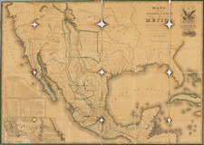
Rare First Edition of the "Treaty Map".
A nice example of the 1828 White, Gallaher & White map of Mexico, Texas, and the American Southwest.
The map is essentially a copy of Tanner's 1826 Map of Mexico, but with Spanish text. The present map is the only edition from its run published by White, Gallaher & White, with all following maps being published by John Disturnell.
The importance derives from the attachment of two later Distrunell editions to the two official copies of the Treaty of Guadalupe Hidalgo, which settled the Mexican-American War. The importance of the Treaty to the settling of the border between the United States and Mexico means that the so-called Treaty Sequence maps (of which this is the first) are of fundamental importance to the mapping of the United States and Mexico.
As it was published in 1828 (and based on a map from 1826), the White, Gallaher & White predates the acquisition by Tanner of Stephen F. Austin's manuscript maps of Texas. Therefore this represents one of the best renditions of Texas to predate the monumental changes that the region would experience in the 1830s.
The California coast is plagued by the cartographic errors that characterized much mapping of that part of the West during the first decades of the 19th century.
Lawrence Martin's “John Disturnell’s Map of the United Mexican States” in Ristow’s A la Carte, pages 207-209 (discussion) discusses the context of the White, Gallaher & White with respect to the Disturnell editions and the Treaty of Guadalupe Hidalgo:
In 1828 a plagiarism of Tanner’s of Mexico was published under a Spanish title by White, Gallaher & White, of New York. Eventually some 24 different editions of this map were published at New York, all but the first by Disturnell, and the map has become widely known as Disturnell’s map. That the White, Gallaher & White map was plagiarized from Tanner’s is suggested not merely by the similarity in titles. The two maps share common errors, for courses of the rivers, and they have the same insets: a large-scale map of the area between Vera Cruz and Mexico, a highly individual table of statistics, and a long table of distances. The latter map used all of Tanner’s explanatory remarks, which were translated word for word....
It is curious that, although White, Gallaher & White’s map was an obvious plagiarism of Tanner’s copyrighted map and both were published in the United States the later map was also copyrighted. Outside its lower neat line, near the right border, appear the words ‘Entered according to Act of Congress, May 31st, 1828, by White, Gallaher & White.’ This suggests that Tanner’s map may have been used by friendly agreement to compile the slightly enlarged Spanish language map, but it seems odd that White, Gallaher & White made no public acknowledgment to Tanner.
The earliest identified edition of Disturnell’s reprint was published in 1846, doubtless because of the outbreak of the Mexican War. Its title information is identical with the White, Gallaher & White map except for date and publisher. The two maps were printed from the same plates, as is indicated by the faint copyright notice, which was incompletely eradicated and shows on the borders of all but two of Disturnell’s editions printed between 1846 and 1858.
As noted by Martin, following the publication of the 1828 White Gallaher & White map, the plates apparently languished in New York until the beginning of the war with Mexico, when they were apparently printed as Disturnell's map, which was issued from 1846 until the early 1860s (in 2010, we handled an edition dated 1862, the latest example we have encountered).
White, Gallaher & White were popular publishers based in New York and working during the 1820s and '30s. They produced, for example, some of Emma Willard's books.
![[Early Montana Territory Shown Above Idaho] Johnson's New Military Map of the United States Forts, Military Posts & all the Military Divisions with Enlarged Plans of the Southern Harbors . . . (Shows Military Departments)](https://storage.googleapis.com/raremaps/img/small/93868.jpg)
![(Panoramic photograph) Camp Travis, Tex. 9/8/1918 East Side [WWI Camp Travis, near San Antonio, Texas, African American Troops]](https://storage.googleapis.com/raremaps/img/small/87312.jpg)