|
||

|

|
|

|
Highly detailed map of Hanoi, published by the Service Geographique de l'Jndo-Chine.
The plan shows a modern European style city, with little sign of the Hanoi which existed only 29 years early when the French took control of the region. The legend identifies over 30 important public facilities, 44 principal pagodas and other urban details.
The map credits "le sergent Lecureur" of the Service Geographique.
The plan was published in connection with the Exhibition of Hanoi which opened on November 3, 1902. The exhibition was intended to demonstrate the achievements of French colonial rule in Indochina, highlighted the accomplishments of Doumer’s administration and the positive impact in transforming the colony.
The French first took control of the region in 1873, at a time when Hanoi was little more than an amalgam of fishing villages on the Red River. From this humble situation, the French designed a classic European style city center, a grid with broad tree lined streets and public buildings and spaces. To do so, the French also altered the topography, filling in lakes and canals. As noted by Mamoru Shibayama:
(1) Urban development planning progressed in the Thang Long citadel and its surroundings during the French colonial period, and in the 1890s, the walls and moats around the citadel disappeared. (2) Ponds and lakes in the old quarter in the Pho Co district decreased in the 1890s, and new streets and urban development emerged. Also, during this period, levee construction provided greater protection against catastrophic flooding, and the development of the old quarter proceeded at an accelerated rate. (3) During the approximately 10 years from 1890 to 1900, urbanization rapidly proceeded westward from the west bank of the Red River to the south side of the Thang Long citadel. . . .
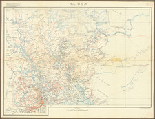
Mapping French Indo-China
At the end of the 19th Century, the Frenchman Jules-Léon Dutreuil de Rhins produced a general map of Indochine which formed the basis for all further mapping of the French " le Bureau topographique du corps d’occupation ". In 1881 a local Land Registry or Cadastre was created to continue the local mapping process and in 1899, the commander Lubanski, head of the Topographic Bureau, developed a comprehensive program that was approved by the Governor General Paul Doumer to execute the project.
The "Bureau topographique en Service géographique de l’Indochine" was ordered to make astronomical and geodetic triangulations, survey maps, make topographic studies of interest to public services, and the drafting and publication of maps.