


|
||

|

|
|

|
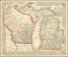
Scarce Charles Walker Morse "cerographic" map of Wisconsin, published in Chicago by Rufus Blanchard in 1855.
The map shows the northwestward expansion of Wisconsin, from the communities on Lake Michigan in the southeast, toward the woodlands of the upper half of the state.
The map includes census data for 1840, '47, and '50, as well as proposed and completed railroads. Confusingly, the makers have eschewed tradition and render the completed railroads with a dotted line.
Cerography was a cheap and quick method for printing, which rose to prominence in America in the middle of the 19th century. It involved engraving a wax-covered metal plate to achieve the image.
Rarity
The map is apparently quite rare, with only three institutional examples recorded. OCLC records the following institutional examples: NYPL, Wisconsin Historical, and the British Library.
![Map of Milwaukee | Population in 18[35] None | In 1843 6068.](https://storage.googleapis.com/raremaps/img/small/68734.jpg)
![[ Superior, Wisconsin ] The Next Great City Watch Us Grow Superior](https://storage.googleapis.com/raremaps/img/small/99914.jpg)