|
||

|

|
|

|
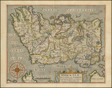
The First Sea Chart of Ireland.
A superb example of one of the great rarities of 16th-century Dutch chart-making, and one of the most desirable maps for the early mapping of Ireland.
The map starts at Dundalk ("Dondalck") in the north (i.e., upper-right), proceeds south past Dublin ("Dubling") and Cork ("Korck"), ending around Kinsale ("Kynsal").
The chart appeared in a stable publication as one of two new maps added in the 1596 edition of the Claesz-published Waghenaer Den Nieuwen Spieghel der Zeevaert. The second new map in the book was of Scandinavia. Schilder found evidence in the 1609 Claesz catalog that the latter map was sold separately, and the same would seem to be the case with the present map of Ireland.
This map is a very fine representation of Kaerius's engraving style, which is heightened by the vibrant original hand-coloring of the scheme associated with the best Waghanaer chart books.
There is an inset in the upper-left corner of the coast between Galway ("Galloway") and Limerick ("Lemrick") titled: Hydrographica descriptio civitatis Galway et Lemric (quæ sunt præcipui portus orarum Occidentalium Hyberniæ) in que quomodo eas adnavigare. vadaq. et brevia evitare liceat, accuratè designatur = Beschriivinge van Galwaii ende Lemrick de princiipaelste havenen aende west siide van Irlandt gelegen hoemen daer in seylen sal ende alle clippen ende ondiepten schouwen sal.
Rarity
Two copies of the map have appeared on the market in the last 20+ years, one in 2008 and 2010, and another in 2014.
![[Ireland / Sea Chart] Carte des Cotes Occidentales D'Irlande Reduite de la Carte de Stuart Amos Arnold et rectifee d'apres les Plans leves par M. MacKenzie Publiee Par ordres du Contr-amiral Decres Ministre de Marine et des Colonies . . . 1803](https://storage.googleapis.com/raremaps/img/small/63682.jpg)
![[Siege of Dunboy] Bere Island](https://storage.googleapis.com/raremaps/img/small/83706.jpg)