|
||

|

|
|

|
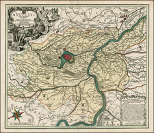
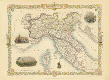
First State of the Great 16th-Century Maps of Northern Italy.
Antique engraved map of northern Italy, from Venice in the northeast to Florence in the south, Lake Geneva in the northwest and Niza in the southwest.
This is the first derivative made after Gastaldi's northern Italy map of 1559. Apparently, there were plans to produce it much earlier than 1570, however, Gastaldi's death in 1565 delayed the publication by five or six years.
Though the map's title suggests that it covers Lombardy, it is in fact a map of the Po River watershed and most of northern Italy.
Bifolco and Ronca 937:
First derivation of Gastaldi's map of 1559, reduced in size and cut in the east. Like the original model, in reality this map is not limited to the territory of Lombardy alone, but encompasses almost all of Northern Italy. The representation of the orography and hydrography is very detailed and graphically suggestive. Although the privilege for printing the copper plate dates back to 1564, due to Gastaldi's death in 1565, this card, engraved by Giorgio Tilman, was published by Antonio Lafreri only in 1570. Top left, within a box, we find the dedication to Cardinal Cristoforo Madruzzo (1512-1578), appointed in 1539 as head of the ecclesiastical state of the Episcopal Principality of Trento. Among other things, the aforementioned postponement of the publication to 1570 made this obsequious dedication useless, because Cardinal Madruzzo had definitively renounced the Principality of Trentino three years earlier, in 1567. We can identify the map with the one mentioned in the Lafreri catalog (n. 42 described as "Lombardia"). The matrix was inherited by Claudio Duchetti and is present in the catalog of the widow of Giacomo Gherardi, heir to Duchetti's chalcographic inventory, of October 1598 (n. 332 described as "Lombardy in two royal sheets"). The matrix was then purchased by Giovanni Orlandi, Hendrick van Schoel and then by Francesco de Paoli. In addition to the reprints described below, it is therefore possible the existence of further unknown editions.
Bifolco and Ronca's 1st state (of at least 3).
107; Ass. Cult. Almagià, pp 146-147.
Antonio Lafreri (1512-1577) (also known as Antoine Lafréry and Antoine du Pérac Lafréry) was a French mapmaker, engraver, and publisher who worked in Italy. Lafreri was born in Franche-Comté and moved to Rome around 1540. Lafreri sold sheet maps but he also bound maps into books for his clients based on their interests and needs. These are the famous Lafreri atlases, important pre-cursors to the modern atlas. He also published well known works such as the Speculum Romanae Magnificentiae (ca. 1575), a collection of engraved views and images of Rome. Lafreri was well-connected to the cartographic networks of the time, collaborating with Giacomo Gastaldi, Battista Agnese, Antonio Salamanca, Donato Bertelli, Paolo Forlani, and others.
![[Padua, Treviso] Patavini Territoriorii, Corographia, Iac. Castaldo Auct. [with] Tarvisini Agri Typus](https://storage.googleapis.com/raremaps/img/small/83544.jpg)