This item has been sold, but you can enter your email address to be notified if another example becomes available.


|
||

|

|
|

|
Stock# 73489
Description
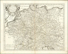
An interesting regional map of Ancient Germany, published in London by Robert Wilkinson.
The map extends west to the Rhine, with Germany divided into 4 principal regions.
Robert Wilkinson was active in London as a cartographic publisher from 1785 to 1825. He produced a number of nice works, including a General Atlas and a re-issuance of Bowen & Kitchen's English Atlas, along with excellent large format separate maps.

![[First Postwar Elections in Germany] Elections au Bundestag 14 Aout 1949 Zone Francaise](https://storage.googleapis.com/raremaps/img/small/78830.jpg)