This item has been sold, but you can enter your email address to be notified if another example becomes available.


|
||

|

|
|

|
Stock# 73446
Description
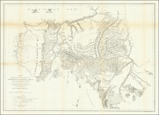
Fascinating map of Oregon Territory, identifying the location of the various Indian Tribes, dates of Treaties with each of the Tribes and significant additional detail.
The map reflects a preparation date which is circa 1855. The map map be George P. Belden's map of the same title, reflecting his time in the region circa 1866-67, with the map being the map which he drafted showing treaty cessions made under Joel Palmer's superintendency in the mid-1850s. The Library of Congress has a manuscript map in two sections of the same title, which is dated 1855 and may well be the source of this printed map.
To date, we have not been able to locate a good bibliographic reference to the map, which is well worthy of additional study.
![[Washington & Oregon] Amer. Sep. No. 38. Partie Des Etats-Unis](https://storage.googleapis.com/raremaps/img/small/93549.jpg)
![Map of Oregon, Washington and Part of Idaho [First Appearance Of Idaho Territory, including western Montana and Western Wyoming]](https://storage.googleapis.com/raremaps/img/small/94211.jpg)