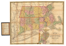
![[ Early Handwritten Annotations ] Connecticut From the best Authorities By John Reid](https://storage.googleapis.com/raremaps/img/small/100909.jpg)


|
||

|

|
|

|
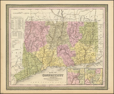
The second map of the State of Connecticut Published in the United States
Fine example of John Reid's map of Connecticut, the second earliest atlas map of Connecticut published in America (following Carey's map of 1795).
The map is divided into counties and shows early roads, towns, rivers, islands, etc.
Nice compass rose.
Following Mathew Carey’s publication of the American Atlas in 1795, the second large format atlas published in America was produced by John Reid of New York in 1796. The project began as an atlas to accompany William Winterbotham’s An Historical, Geographical, Commercial and Philosophical View of the United States, but was also sold separately under the title The American Atlas.
Reid’s atlas included 20 maps. In addition, John Russell’s plan of Washington, D.C. is also bound into some copies of the Atlas. Reid’s atlas was a collaborative work, with 9 of the maps engraved by Benjamin Tanner, 5 by David Martin, two by D. Anderson and one each by John Scoles and John Roberts. Two of the maps do not include engraving credits. Each of the engravers was probably working in New York (including Tanner, who had not yet relocated to Philadelphia). According to the various entries for the maps in Wheat & Brun, the cartographic content of the maps is drawn largely from Carey’s first atlas of 1795.