|
||

|

|
|

|
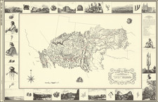
Map Illustrating The Earliest Survey and Reconnaissance By The Santa Fe Railroad To Connect San Diego to a Transcontinental Railroad
Highly important hand drawn railroad survey map, examining the prospective routes for a railroad connecting San Diego to the lines of the Atchison, Topeka & Santa Fe Railroad ("Santa Fe"), drawn to accompany a report dated December 8, 1879.
Drawn by famed mapmaker and engineer William R. Morley, Chief Engineer of the Sant Fe Railroad, the present map was used by the directors of the Santa Fe Railroad, along with the December 8, 1879 report referenced on the map, to make the determination to pursue San Diego as a western terminus for the railroad, a decision which would finally connect San Diego to the east by rail.
The map reflects the reconnaissance and survey work of George B. Wilbur, Lucius G. Pratt and the Santa Fe's Chief Engineer William R. Morley to examine prospective routes to San Diego, either via the Cajon Pass or the San Gorgonio Pass to the north. This proposal would result in the successful connection of San Diego to the Transcontinental Railroad, although it would take another 5 years before the first trains from San Diego would reach San the Santa Fe lines.
At the time of the map's creation, San Diego had a population of about 2,500 and 4,800 in the entire county. The first printed topographical maps of San Diego County would not be completed for another 2 decades, making the compilation of the map a significant project. The map was likely constructed from hand drawn township and range surveys held in Los Angeles at the General Land Office.
Signed by Morley, the map shows a possible routes in solid and dashed blue lines from San Diego northward, with two prospective routes around Mount Soledad (including through La Jolla), then north along the coast to the San Luis Rey River, where 3 prospective routes were illustrated to the north, one along the coast and two toward Fallbrook and Temecula, which met at Temecula Canyon, before proceeding northeast into today's Riverside County. Ultimately, the line would have reach the desert region northeast of the San Bernardino Mountains and onward toward Needles, California, and the Colorado River, via one of two mountain passes, either the Cajon Pass or the San Gorgonio Pass to the east.
Morley's map includes the outlines of a number of the San Diego and Southern Riverside Ranchos, along with topographical (rivers and mountains) and red lines, illustrating the primary roads in the region. A number of elevations are also shown for the primary inland settlements and places listed.
The focal point of the map is explained in blue pencil. The pencil note at the bottom left tells the primary story
Blue lines probable routes into San Diego See report - Dec 8th 1879 W. R. Morley
About 20 settlements are shown in the whole of San Diego County, including Julian, which was in the midst of a mining boom and was then the second largest city in the county.
Connecting San Diego By Rail
Beginning shortly after arrival of Alonzo Horton in 1867, San Diego's prominent citizens worked to persuade the railroads to connect to San Diego. In 1868, the San Diego & Gila Railway was planned, with the intent of connecting San Diego and Fort Yuma, a venture which failed to gain a land grant and ended in bankruptcy. Frank Kimball, founder of National City, attempted to persuade Charles Crocker to bring the Central Pacific to San Diego, an effort which failed when Kimball refused to sell six miles of prime bayfront real estate to the Central Pacific. Crocker responded that Kimball would never live to see a railroad built to San Diego. Never would a competitor of the Central Pacific be allowed to interfere.
The first significant progress was in 1873, when Horton and Kimball made a pitch to Colonel Thomas Scott, president of the Texas & Pacific Railroad, to use San Diego for its western terminus While initially encouraging, the effort failed when the Southern Pacific completed its line to San Fancisco via Los Angeles, Yuma, El Paso and New Orleans.
As noted by Lowell,
San Diego business leaders realized that they would have to gain a powerful ally to counter the tremendous power of the Central Pacific. Frank Kimball . . . [also] approached Jay Gould to help San Diego obtain a railroad. . . . Gould replied to Kimball’s inquiry: “I don’t build railroads: I buy them."
Undaunted, Kimball went to Boston to negotiate with the Directors of the [Atchison Topeka &] Santa Fe in 1879. They agreed, after sufficient promise of money and land, to make San Diego the western terminus of their line. Thomas Nickerson, President of the Santa Fe, promised to send representatives to San Diego to look over the proposed roadway. Kimball wrote to Nickerson, “For God’s sake send men who can’t be bought by Stanford."
* * *
Late in 1879 the Santa Fe railroad purchased a one-half interest in the St. Louis and San Francisco Railroad, and thereby became owners of the Atlantic and Pacific Company. This purchase gave the Santa Fe access to the Atlantic & Pacific land grant in California. The Santa Fe changed its expansion plans and decided to build to Needles. . . Kimball returned to Boston and renewed his offer to ensure the completion of the earlier planned route to San Diego. Kimball promised to give the railroad 10,000 acres of land, create a Land Company in San Diego to manage the railroad land sales, and offered an additional 6,000 acres to start that company. An agreement was reached that the Boston directors would form a new company to build from the bay of San Diego to a connection with the Atlantic & Pacific road. On October 12, 1880 the California Southern Railroad was chartered. The Directors of the Santa Fe also sat on the Board of California Southern. Thomas Nickerson was president of both lines. Frank Kimball sat on the Board of Directors for the California Southern.
Kimball's efforts were successful in part. As noted by Dodge,
Kimball returned buoyant with hopes. Representatives George B. Wilbur, Lucius G. Pratt and Chief Engineer William R. Morley, the latter of "Royal Gorge [Railroad War]" fame, were sent out from Boston. Morley reported that there were no serious physical obstacles in the way between San Diego and Yuma, so surveys were started for a line directly east from San Diego, only to be stopped by orders from Boston . . .
As a result of the planning, local investors and the San Fe formed the California Southern Railroad and by the end of 1880, over $3,000,000 had been raised to build a railroad to San Diego and National City. Work commenced in 1881, via a planned route from National City to Oceanside, then through Temecular Canyon north to Colton, near San Bernardino. The first locomotive for the new line was shipped east from Boston, arriving in National City on July 13, 1881, with the line through to Colton completed on August 14, 1882.
The line operated from November 1882 to March 1884, with telegraph lines run and offices in National City, San Diego and Fallbrook. Unfortunately, the massive rainstorms of 1884 resulted in tremendous damage to bridges and the road bed, forcing the line to close on March 19, 1884.
It would take until November 1885 and significant restructuring of debt and re-alignment of national railroad interests, before the line would be completed through to San Bernardino, ushering in the first real economic boom in San Diego. By 1890, the popuation grew from 2,800 to 16,000, with unofficial estimates suggeting the real population peaked at closer to 30,000.
Morley
William R. Morley had an impressive career as a mapmaker in the west, including the publication of a rare separately published map of New Mexico Territory, published in 1873. By the mid-1870s, Morley was working for the Santa Fe Railroad. The Arizona Silver Belt, Decemer 20, 1876 notes:
Mr. W. R. Morley, who has had charge of the preliminary survey of the New Mexico & Southern Pacific branch of the Atchison, Topeka & Santa Fe Railroad, from Trinidad to Fort Yuma, gives us some interesting points regarding the work. The line will be an exceedingly easy one to construct, there being few grades beyond Albuquerque to exceed forty feet to tne mile, and most or them not over twenty feet. . . . The Southern Pacific Railroad Company will be likely to extend their road during the coming winter east as far as Maricopa Wells one hundred and sixty-five miles from Fort Yuma and possibly to Tucson, a distance of two hundred and fifty miles. That company is in good financial condition and able to push forward to meet the Atchison, Topeka & Santa. Fe at any time.
Morley would rise to become the chief engineer for the Santa Fe Railroad and later serve as editor of the The Cimarron News and manager of the Maxwell land grant in Cimarron. Morley died in 1883 from an accidental shooting in Mexico.
Rarity
The map is a unique survival. We have been unable to locate any similar map, printed or hand drawn.
We were not able to discern the name of the maker, who was almost certainly an agent for the Santa Fe Railroad.
-Leslie, The Entrance of the Santa Fé Railroad into California, Pacific Historical Review Vol. 8, No. 1 (March 1939), pp. 89-96.
-Dodge & Middlebrook, The California Southern Railroad: A RAIL DRAMA OF THE SOUTHWEST. The Railway and Locomotive Historical Society Bulletin No. 80 (May, 1950), pp. 10-46.