|
||

|

|
|

|
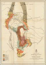
Excellent map of the region between the Great Lakes and the Gulf Coast, following the course of the Mississippi River.
The map tracks the Mississippi River Valley from the region identified as the Sioux Indians of the East and Sioux Indians of the West, with a number of other Indian tribes named, including the Cheraquis, Chouanons, Chicachas, Osages, Canses, Mascoutens, Panis and Renards.
Of particular note is the location of "Etablissement Francois" (French Settlement), which corresponds with the general location of Fort Chartes, Kaskaskia and Sainte Genevieve, Missouri, an early French settlement on the Mississippi River and the first settlement west of the Mississippi River. Founded around 1735 by "Canadien habitants" and migrants from settlements in the Illinois Country just east of the Mississippi River, Ste. Geneviève is the oldest permanent European settlement in Missouri and one of the oldest colonial settlements west of the Mississippi River. This area was known as New France, Illinois Country, or the Upper Louisiana territory. There is some controversy regarding the original settlement date, as traditional accounts suggested a founding of 1735 or so, but the historian Carl Ekberg has documented a more likely founding about 1750.
Jacques-Nicolas Bellin's map of 1755, the first to name Ste. Genevieve in the Illinois Country, showed the Kaskaskia natives on the east side of the river, but no Indian village on the west side within 100 miles of Ste. Genevieve. While it is most likely Fort Chartes that is shown here, the position of the settlement appears to be west of the Mississippi, suggesting a possible location of Ste. Genevieve prior to Bellin.
Includes a fair amount of Texas, including notes on De La Sale and a reference to Cenis and Teijas. Many Indian Villages shown, along with early French Forts.
An excellent pre-French & Indian War map. From the 1749 edition of De Vaugondy's Atlas Portatif Universel et Militaire.
Gilles Robert de Vaugondy (1688-1766) and Didier Robert de Vaugondy (1723-1786) were influential figures in the realm of 18th-century French cartography. Originating from Paris, their contributions to mapmaking were significant during an era of expansive geographical exploration.
Gilles Robert de Vaugondy entered the world of cartography not through family tradition but through personal interest and the budding opportunities of his time. Born in 1688, he worked during a time when Paris was becoming a central hub for cartographic activities. Gilles often incorporated the latest findings from explorers into his maps, making them sought-after for their contemporary relevance. His connections weren't limited to his immediate circle; he frequently interacted with other key mapmakers, staying updated on the latest techniques and findings.
His son, Didier, was born in 1723 and had the advantage of growing up surrounded by maps and globes. While his father was renowned for maps, Didier made a name for himself in the field of globemaking. His globes were some of the most precise and detailed in France, gaining recognition even among the royalty. In addition to his work in cartography and globemaking, Didier had a keen interest in education, especially after the expulsion of the Jesuits from France. He stepped in to produce geographical educational materials, fulfilling a newfound need.
The maps and globes produced by the Vaugondys remain an enduring testament to the peak of French cartography during the Enlightenment. Their works, characterized by precision and the inclusion of contemporary findings, helped to shape our understanding of the world during a transformative period in European history.

![[ Oil & Gas in Texas and Louisiana ] Gulf Coastal Region Texas and Louisiana Showing Oil, Gas & Sulphur Fields & Prospects Pipe Lines & Refineries](https://storage.googleapis.com/raremaps/img/small/101409.jpg)