


|
||

|

|
|

|
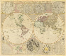
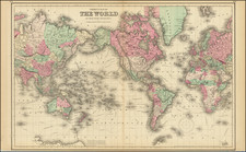
Erudite Eighteenth-Century Wall Map of the World
Interesting double-hemisphere world map with additional tables and figures; a thought-provoking, large wall map, this 1780 edition includes the tracks of Captain Cook’s first two voyages.
Dunn's map is one of the most popular and recognizable from this period, as Dunn’s world maps were the map of choice for a number of atlases published by Jefferys, Sayer and Bennett, and Laurie and Whittle over a thirty-year period. The map was revised several times, with this example, bearing the Sayer and Bennett imprint, quite possibly the most sought after thanks to the addition of Cook's first (1768-1771) and second (1772-1775) voyages.
The map is a fount of information; as the title indicates, it is offers “Curious & Useful Particulars in the Solar, Starry, & Mundane Systems.” The document includes both the terrestrial world map and a celestial map in northern and southern hemispheres. Surrounding the earthly spheres are several diagrams. At center below them is a diagram of the face of the moon. These are flanked by a table of the dimensions of the solar system and of the placement of the sun in the ecliptic with declination. In the top right corners is an analemma—a projection that allows for the calculation of the latitude and longitude of fixed stars, including the sun—and in the lower right corners are instructions as to its use. In the left top corner is a model of the solar system with individual planets drawn as seen from a telescope.
The map is also a geography primer. It defines terms important to the study of geography, shows the seasonal rotation of the globe, provides a Mercator Projection map, the art of dialing on a common globe, and the cause of the tides. In the lower left corner is a universal scale, revealing Dunn’s mastery of mathematics as well.
The geographic detail is rich. Africa has many blank spaces, revealing the limits of European knowledge there. One kingdom that is included is Monomotapa in the southeast, a polity with access to gold deposits and therefore a fixture in the European geographic imaginary. New Holland is attached to Van Diemen’s Land and there is no Antarctic continent included.
In the west, Greenland is connected to North America, as the extent of the area’s ice fields and landmasses were not well understood. Alaska is only hinted at, although it would be delineated quickly in the decades following this map’s publication.
The most striking details of the map are the ship’s tracks showing significant voyages of the four decades preceding publication.
- Bouvet de Lozier led an expedition in 1738-9 in the South Atlantic and Indian Oceans. He sighted land, which he called Cap de la Circoncision, and reported massive icebergs at sea.
- In the North Pacific are the tracks out and back of “Tchirikow” and de l’Isle. They were part of the second Bering Expedition which lasted from 1733 to 1743. Louis De L’Isle de la Croyere sailed with Captain Alexsei Chirikov (Tchirikov) to discover the fictional De Gama’s Land, or Companies Land. De L’Isle died in the attempt, but his papers survived and did not quell rumors of a large island stretching between Asia and America.
- Nearby is another track, snaking through what is now the Bering Strait. This is the track of Fedot Alekseev and Semyon Dezhnev, who sailed from the Kolma River around the Chukchi Peninsula and into the Pacific in 1648, proving that Asia and North America were not connected.
- Running around the entire world is Anson’s route from 1740-44. Anson had been ordered to harass Spanish shipping on both sides of the Pacific. He did so, capturing a Spanish treasure galleon near Manila, and returned home a hero, especially after the publication of his bestselling account in 1748.
- Another circumnavigation included here is that of Louis Antoine de Bougainville. From 1766-9 he completed the first French circumnavigation; his was also the second European ship to visit Tahiti.
- In the far north is the track of “Capt. Phipps going out.” Commander Constantine Phipps, the second Baron Mulgrave, took the Racehorse and the Carcass north on the British Naval North Polar Expedition in 1773. They were thwarted by impenetrable ice just north of 80°N.
Also zig-zagging across the world are the tracks of Captain James Cook’s first and second voyages. His third expedition was in the Atlantic, sailing home, when this map was published in June 1780. They would arrive on October 7, 1780 bearing the news of Cook’s death in Hawai’i.
Cook's first voyage (1768-1771)
The Transit of Venus is one of the rarest predictable astronomical phenomena, occurring twice in eight years and then not again for over one hundred years (in a 243-year cycle). Observing the time it takes for Venus to transit across the sun can help to calculate the size of the solar system and the distance from the Earth to the Sun. In 1761, scientific societies sought to record the Transit from posts around the world. However, many of the observations were flawed or thwarted by the weather, especially those arranged, in haste, by the Royal Society of London. Determined to not repeat the same mistake, the Royal Society planned a South Sea voyage to view the 1769 Transit in concert with the Royal Navy, as the southern Pacific would be one of the places where the Transit was visible.
The Admiralty chose Lieutenant James Cook to command the expedition, based on his aptitude for charting and instrumentation. He was joined by Joseph Banks, a wealthy young botanist, and his retinue of scientists and artists. In addition to observing the Transit, Cook was secretly instructed to seek out and claim any potentially-useful territory or resources that his ship, Endeavour, came across.
Cook and his crew sailed from Plymouth on August 25, 1768. It sailed south, to Tierra del Fuego, and then to its destination for the Transit: Tahiti. There, three groups observed the Transit, although their results were imprecise. When the Endeavour left Tahiti in July 1769; on board was a new member of the party, the Rai’aitean priest and navigator Tupaia, along with his servant, Taiato.
The ship headed south, arriving in New Zealand in early October. There, Tupaia found that he could understand and speak with the local people, the Māori. However, this did not prevent several violent incidents that resulted in deaths. While charting the coastline, Cook and the voyage astronomer, Charles Green, observed the Transit of Mercury. The ship sailed round the southern tip of the South Island, proving it was not connected to a southern continent.
Next, the Endeavour set out east, encountering the east coast of Australia in April 1770. They were the first Europeans to do so. After stopping at a place they called Botany Bay, the ship turned north, skirting the coast. Endeavour ran aground on the Great Barrier Reef; while the ship was saved, they had to stop for repairs at Waalumbaal Birri, or Endeavour River. Here, the Europeans saw their first kangaroo and learned its name from the local people, the Guugu Yimithirr. They nearly ran aground again, but narrowly averted disaster and made for Jakarta, then known as Batavia.
In Batavia, many members of the crew became ill. More than two dozen men, including Sydney Parkinson, the voyage artist, the aforementioned Charles Green, and Tupaia, died in Jakarta or at sea soon thereafter. Weakened, the Endeavour called at the Cape of Good Hope and returned to the Thames in July 1771.
Cook's second voyage (1772-1775)
Cook’s first voyage was considered a success. The Admiralty chose to send him to the Pacific again, this time to focus on finding and charting Terra Australia incognita, if it existed. This time, Cook was in command of the Resolution and accompanied by the Adventure, captained by Tobias Furneaux.
The ships departed Plymouth on July 13, 1772. They made for the Cape of Good Hope and then sailed south, in search of land. They reached an ice sheet and could not find a break to sail through. The crew melted ice for fresh water and the expedition artist, William Hodges, drew eerie pictures of looming icebergs. On January 17, 1773, the ships crossed the Antarctic Circle, the first ships known to have done so.
Separated in fog, the ships headed toward New Zealand. They rendezvoused in Queen Charlotte Sound, where they traded with the Māori. The Māori inquired as to location of Tupaia and were sad to hear that he had died.
The ships returned to Tahiti, where they found the politics of the island had shifted and there was a new leader, Tu, to consult. Mai, a Rai’atean man, joined the Adventure, while Hitihiti joined the Resolution. The former became the first Polynesian to visit Britain, while Hitihiti returned home after sailing to Tonga, the Antarctic, New Zealand, and Easter Island.
Cook and his men next sailed to Tonga and then back to New Zealand. En route, the ships were separated again. Resolution left for southern waters without Adventure; Furneaux decided to return to Britain, leaving Cook in the Antarctic.
In December 1773 and January 1774, Resolution crossed the Antarctic Circle for the second and third times. They reached 71°10’ South, the farthest south any ships had sailed; the record would stand until 1823. He had decidedly proven that the great southern continent was nothing more than a myth.
Returning north, Cook called at Rapa Nui, or Easter Island, and his men marveled at the Moai, large statues that stand guard on the island. The Resolution returned to Tahiti, and then called at Niue, Nomuka, Vanuatu, New Caledonia, and Norfolk Island. After another visit to New Zealand, they sailed east to Tierra del Fuego. In the Atlantic, Cook named South Georgia and the South Sandwich Islands. On the homeward stretch, Resolution visited St. Helena and then anchored in Portsmouth on July 30, 1775.
Samuel Dunn (bap. 1723-1794) was a teacher of mathematics and navigation who published, among other things, maps and charts. Although information about his early education is lacking, by age nineteen he was leading his own school and teaching writing, accounting, navigation, and mathematics in Devon. In 1751, he moved to London, where he taught in several schools and tutored privately.
By the 1760s, Dunn was known as a respected astronomer and had published a range of textbooks on math, navigation, and astronomy. After the publication of the Nautical Almanac, Dunn acted as a certifier of ships’ masters under the new system, on behalf of the Board of Longitude. He performed similar work for the East India Company, as well as made charts of the East Indies. In 1776 he published A New Variation Atlas and, in 1777, A New Epitome of Practical Navigation, or, Guide to the Indian Seas. By 1780, he was named editor of the New Directory for the East Indies, which included his own charts. In 1786, he released a pioneering study, Theory and Practice of Longitude at Sea. He also designed several instruments for navigation.
Dunn died at his home in Fleet Street in January 1794. His books and maps were auctioned at Sothebys in a sale of over 1,000 lots. Many of these were bought by Alexander Dalrymple, hydrographer of the East India Company and soon-to-be-named first head of the Hydrography Office.
![[Heightened in Gold] Nova Totius Terrarum Orbis Geographica Ac Hydrographica Tabula Autore N I Piscator . . . 1652](https://storage.googleapis.com/raremaps/img/small/82696.jpg)
![[ Triangulum ]](https://storage.googleapis.com/raremaps/img/small/88313.jpg)