


|
||

|

|
|

|
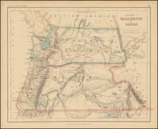
Second state of Colton's Map of Wyoming Territory and Dakota Territory, along with most of Montana Territory.
Rare detailed map of Wyoming and Dakota Territories, first published in 1868. The present example is the first state of the map to show counties in Wyoming.
This is one of the earliest regional maps of Wyoming to appear in a commercial atlas and a truly unique configuration.
Excellent early detail and annotations throughout.
G. W. & C. B. Colton was a prominent family firm of mapmakers who were leaders in the American map trade in the nineteenth century. The business was founded by Joseph Hutchins Colton (1800-1893) who bought copyrights to existing maps and oversaw their production. By the 1850s, their output had expanded to include original maps, guidebooks, atlases, and railroad maps. Joseph was succeeded by his sons, George Woolworth (1827-1901) and Charles B. Colton (1831-1916). The firm was renamed G. W. & C. B. Colton as a result. George is thought responsible for their best-known work, the General Atlas, originally published under that title in 1857. In 1898, the brothers merged their business and the firm became Colton, Ohman, & Co., which operated until 1901, when August R. Ohman took on the business alone and dropped the Colton name.
![(Nothern Half) [Bancroft's Map of the Pacific States]](https://storage.googleapis.com/raremaps/img/small/54924.jpg)
![[Early Montana Territory Shown Above Idaho] Johnson's New Military Map of the United States Forts, Military Posts & all the Military Divisions with Enlarged Plans of the Southern Harbors . . . (Shows Military Departments)](https://storage.googleapis.com/raremaps/img/small/93868.jpg)