


|
||

|

|
|

|
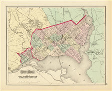
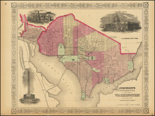
Scarce plan of Washington, the District of Columbia and contiguous regions of Virginia and Maryland, from Gray's Atlas of the United States.
Shows Potomac City, Uniontown, Mt. Pleasant Village, early roads, buildings, the US. Arsenal, bridges, the Washington Monument, Smithsonian, Navy Yard, Powder Magazine, early bridges and a host of other details shown.
The National Course race track. US Lunatic Asylum and Columbia Institute for the Deaf and Dumb are among the more fascinating points of interest shown on the map.
O. W. Gray was a publishing firm based in Philadelphia. Later, they published as O. W. Gray & Son. They published atlases in the late nineteenth century. Gray's National Atlas was one of the most successful commercial ventures of the 1870s and one of the last to employ hand coloring on maps.

![[United States Capitol]](https://storage.googleapis.com/raremaps/img/small/83399.jpg)