


|
||

|

|
|

|
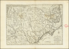
A Revolutionary War Era Map of Georgia
Finely executed map of the Province of Georgia, published at the outset of the American Revolution
The map shows Georgia, extending from the Savannah River and parts North to the Apalachicola River, and touching on East and West Florida.
The map shows Fort Charlotte, Fort Argyle and Fort Moore on the Savannah River. The map was intended to illustrate Georgia shortly after the British Southern Campaign commenced in Georgia.
In 1778, General Sir Henry Clinton in New York ordered Lieutenant Colonel Archibald Campbell to invade Georgia with 3,000 troops, and to restore the state to British rule, thus setting an example for the restoration of other former colonies. Prior to Campbell's attack upon Georgia, General Augustine Prévost conducted a cattle raid into the lower Georgia counties.
On December 28, 1778, Campbell's army landed unopposed on a bluff below Savannah, advanced through the swamps by an unguarded path, and overwhelmed General Robert Howe's defenders of Savannah. Campbell waited until January 12 for the arrival of Prevost's Royal Americans and Brown's Rangers from Florida, and on January 24 began a march with Brown's Rangers to Augusta in the backcountry. Except for a skirmish at the Burke County courthouse involving Brown's Rangers, Campbell was unopposed.
Campbell took possession of Augusta on January 31, 1779. The southern strategy seemed to be successful when 1,400 men came into Augusta to sign up in the royal militia. However, the British Indian allies were badly delayed, and on February 14 several hundred Loyalists were cut off at Kettle Creek in Wilkes County by South Carolinians under Andrew Pickens and Georgians under Elijah Clarke and John Dooly. Alarmed by the approach of 1,200 North Carolinians under General John Ashe, Campbell withdrew from Augusta on the same day as the Battle of Kettle Creek. Ashe's troops, Samuel Elbert's Georgia Continentals, and Andrew Williamson's South Carolina militia followed the retreating British. On March 3 the British, now commanded by Lieutenant Colonel James Mark Prevost, turned upon the Americans and routed them at the Battle of Brier Creek.
Fort Moore
Fort Moore is located across from Augusta and near New Savannah. Fort Moore was constructed in 1715 to protect the Savannah Town settlement, a defunct settlement that was located in the colonial years on the Savannah River below the Fall Line in present-day Aiken County. In the 1670s, the Westo had a village here, but they were displaced by the Savannah (as the English called a local Shawnee band) in a trade war, and it became known by 1685 as Savannah Town. The English colony had traders who did a lucrative business in dressed skins with the Savannah Shawnee. Fortified as a frontier post, the settlement developed and ferry service was established across the river. The town was gradually overtaken by its competitor of Augusta, Georgia, established in 1735 five miles upriver and closer to Indian settlements. Traders here intercepted commerce, sending it to their port of Savannah on the coast. By 1740 Savannah Town was declining, and by 1765 the village was abandoned and the fort closed during the Cherokee War of 1760. Fort Moore harbored militia and refugees, but by 1765, the fort was closed.
One of the few Colonial American Maps to focus on Georgia.


![[Untitled Coast chart of North Carolina, South Carolina, Georgia, and Florida, with insets of the harbor of Charleston, S.C. and the entrance of the Saint Johns River]](https://storage.googleapis.com/raremaps/img/small/91737.jpg)
