This item has been sold, but you can enter your email address to be notified if another example becomes available.


|
||

|

|
|

|
Stock# 73273
Description
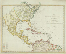
One of the Earliest Printed Maps of Kentucky
Rare map of Kentucky, just 3 years after it became a state.
The map shows mountains, rivers and early settlements, including Cincinnati in the north and Fort Massac (Illinois) in the west.
Condition Description
Minor soiling and offsetting.