


|
||

|

|
|

|
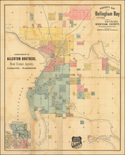
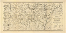
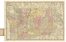
One of the Largest of the Rare 19th-Century Maps of Washington.
Fine large map of Washington, prepared with the field notes and assistance of C. H. Amerine of Spokane Falls; thus the information for Eastern Washington and Northern Idaho is unusually detailed and accurate.
Amerine was a noted map-maker who published two maps of Washington in Spokane Falls (in 1888 and 1889; both were smaller than this map), as well as a large sectional map of Washington, Oregon, Idaho and Western Montana in Tacoma in 1891.
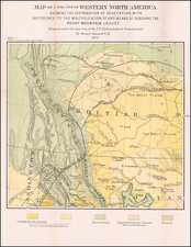
The scale of this map, at 8 miles to one inch, shows remarkable detail. Among the mining districts shown are the Clark's Fork Mining District (Western Montana), the Metaline Mining District (Eastern Washington), the Kootenai Mining District and the Rock Creek Mining District (British Columbia), and the Colville Mining District, among others.
The Coeur D'Alene (or Silver Valley) mining district traces its history to the 1860s when gold was discovered in the region, but mining because more formalized and serious in the 1880s. In the 1890s the region was the site of two major labor confrontations: the Coeur D'Alene Strike of 1892 and the Coeur D'Alene Confrontation of 1899. The former event spurred the creation of the Western Federation of Miners.
The map was probably published because of two events: Washington Statehood in 1889 and the Coeur D'Alene mining boom of the 1880s and 1890s.
Rarity
The map is very rare; we note a handful of 1890 or '91 copies in OCLC, but no copies of this 1892-95 edition anywhere.
This is the first time we have had any edition of the map.
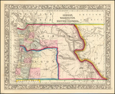
Rand McNally & Co. is a large American map and navigation company best known for its annual atlases. The company got its start in 1856, when William Rand opened a print shop in Chicago. He was joined in 1858 by a new employee, Andrew McNally. Together, the men established their namesake company in 1868. Originally, the company was intended to print the tickets and timetables for the trains running to and through Chicago; their first railway guide was published in 1869.
By 1870, they had shifted from just printing to publishing directories, travel guides, and newspapers. Their first map appeared in 1872 in a railway guide. The map was produced using a new wax engraving method, a cheaper process that gave the company an edge.
By 1880 Rand McNally had entered the education market with globes, wall maps, and geography texts for students. In 1923, Rand McNally published the first Goode’s World Atlas, named after its editor, Dr. J. Paul Goode. For generations afterward, this would be the standard classroom atlas.
In 1899, William Rand left the company, but McNally and his family remained, controlling the company for over a century. In 1904, they published their first road map intended for automobiles and by 1907 were publishing Photo-Auto Guides, which combined photography and mapping to help drivers. In 1924, they produced the Auto Chum, a precursor to their famous road atlases. Rand McNally would remain the leader in road maps and atlases throughout the twentieth century.
In 1937, Rand McNally opened its first store in New York City. Ever on the frontier of technology, Rand McNally pioneered the scribing process for printing tickets in 1958 and printed their first full-color road atlas in 1960. Arthur Robinson developed his now-famous projection of Rand McNally in 1969. By the 1980s, the company was exploring digital reproduction and digital databases of maps for truckers. In the 1990s, they lead the charge to develop trip-planning software and websites. Today, most of its products are available online or in a digital format, including maps for tablets and phones.