


|
||

|

|
|

|
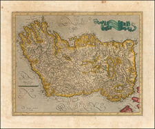
Finely executed map of Ireland, published in London by Richard Blome.
Based on the cartography of John Speed, Blome's map appeared in the first edition of 'Britannia', Blome's larger series of county maps.
At the left are the crests of four noblemen, as well as dedications to them from Blom
- Arthur [Capell] Earl of Essex
- Sir Robert Ridgeway
- Right Hon. Richard Earl of Arran
- John Lord Baron of Kingston
Richard Blome was one of the most active map-publishers of his day, working between about 1667 and 1705. His principal publications were the 'Geographical Description of the World', and two county atlases, the 'Britannia', published in 1673, and 'Speed's Maps Epitomiz'd', published in 1681. Blome first began engraving maps for his Geographical Description Of The Four Parts Of The World in 1667. The completed volume was in small folio, and contained 24 maps (plus one duplicated), engraved by Francis Lamb, Thomas Burnford, and Wenceslaus Hollar.

![[ Ireland ] Hyberniae Regni in Provincias Ultoniam, Connachiam, Lageniam, Momoniamq divisi Tabula Accuratisima editore Covens et Mortier Amstelo-Batavio](https://storage.googleapis.com/raremaps/img/small/99667.jpg)