|
||

|

|
|

|
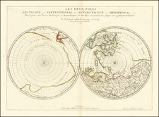
Antarctica and Australia Imagined
Fine map of the southern hemisphere with a fascinating, conjectural southern continent and an intriguing outline of Australia.
The map was published by the Prussian Academy of Sciences while it was under the leadership of famed mathematician Leonhard Euler and when the question of the shape and extent of Antarctica was a topic of intense debate amongst Enlightenment scholars.
Based on a 1714 map by Guillaume Delisle, the hemispheric projection stretches to the Equator. Originally drafted in 1754, likely in response to a similar map presented to the Académie des Sciences (Paris) by Philippe Buache, the map includes most of South America and sub-Saharan Africa, with mountains emphasized on both continents.
These mountains are important as the Prussian Academy map is hypothesizing the size of a possible southern continent based on the perceived extension of mountain ranges toward the South Pole. These underwater mountain ranges, which emerge as islands or re-emerge as larger landmasses, were theorized by Philippe Buache in his work on global watersheds. He also published similar maps with a conjectural Antarctica in the mid-eighteenth century. However, Buache's map included a large internal sea, whereas that feature has been omitted here.
Circling the pole is a massive outline with shadow coasts. In the interior are mountain ranges, continuations of the mountains of New Zealand and Australia and Africa, as notes explain. The vast size of this Terra Australis is the result of the combination of several voyages; isolated sightings of land and incomplete reports have been correlated and joined into the huge form seen here. Notes ringing its shores say that Spanish, Dutch, and French voyages from the sixteenth, seventeenth, and eighteenth centuries saw signs of land like driftwood, birds, and nearby islands.
The edges of the continent are linked to actual islands. In the southern Atlantic, Cap de la Circoncision (today Bouvet Island) is part of the coast rather than insular. This isolated shore was sighted by Bouvet de Lozier on his 1738-9 expedition in search of a south land. Bouvet spotted the island through the fog, was not able to land, and did not circumnavigate his discovery, thus not clarifying if it was an island or part of a continent. This obscurity and potential made it of intense interest to geographers.
Another outpost of this grand southern continent is New Zealand. Abel Tasman, in the employ of the Dutch East India Company in 1642-1643, sailed south of New Holland to Van Diemen’s Land and then to a shore new to Europeans farther east in the Pacific. This was New Zealand. Tasman then returned north and then west to Batavia. Tasman’s track is noted as a dashed line on this map.
There are also other ships’ tracks including that of Magellan, Mendaña, La Roché, Le Maire and Schouten, Halley, and Dampier.
- Ferdinand Magellan is widely celebrated as the first commander to lead a voyage around the world. While one of his ships, the Victoria, did limp back to Spain after three years with only eighteen men, Magellan himself had died in the Philippines.
- Alvaro de Mendaña led a voyage from Peru to the Solomon Islands in 1567. However, he could not take accurate longitudinal readings. He was tasked with again finding the islands in 1595; however, he died en route and the voyage did not accurately locate the Solomons for a second time.
- Anthony de la Roché was an English merchant. He commanded a voyage from southern Chile to Brazil in 1675. The ship was blown off course, far into the Atlantic Ocean. He and his crew saw an island, which is noted on this map. This was most likely South Georgia, the same island seen by the Lyon in 1756; however, the Lyon’s sighting is noted on this map as much farther east than La Roché’s island.
- Le Maire and Schouten led an attempt to undermine the Dutch East India Company monopoly on the entrance to the Pacific via the Straits of Magellan. They found an alternative route around Cape Horn via a strait now named for Le Maire. They then went on to complete a circumnavigation of the globe from 1615 to 1617.
- Edmund Halley led three voyages in the Paramore making observations on magnetic declination. In 1698 and 1699 he sailed in the far southern Atlantic and saw large icebergs.
- William Dampier, after writing a celebrated voyage account of his years as a buccaneer, was given command of HMS Roebuck. From 1699 to 1701 he led an ill-fated expedition that sunk the Roebuck yet also led him to land on eastern Australia.
Australia and Quiros
Of especial interest here is another track that crosses the Pacific, that of Pedro Ferdinand de Quiros. Quiros accompanied the second Mendaña expedition. As a result, he became obsessed with finding the southern continent.
After returning to Spain, Quiros convinced authorities that he could find Terra Australis if they gave him ships and supplies. He set out in 1605 and eventually landed in Vanuatu. He mistook one of the islands for the fabled continent and called it Australia del Espiritu Santo. The largest island in the chain is still called Espiritu Santo today.
Quiros intended to set up a colony on the supposed continent. He performed a series of elaborate possession rituals and founded a city he called Nueba Hierusalem. The “city” was nestled between two rivers which Quiros called the Jordan and the San Salvador (likely today’s Jordan and Vitthié Rivers). However, his crew forced him to leave. Quiros returned to Mexico, but his second-in-command, Torres, sailed west, through the strait now bearing his name. Due to state secrecy, however, the strait remained largely unknown until the 1760s.
Upon his return, Quiros revved up his campaign, lobbying once again for a voyage to return to his supposed southern continent. To gain support, Quiros wrote at least fifty memorials to advertise his successes and lay out his plans. Fourteen of these were printed between 1607 and 1614.
The most widely circulated was the Eighth Memorial. In it, he describes Australia del Espiritu Santo to be as wide as Europe, Asia Minor, the Caspian Sea, and Persia combined, “in its outline it quarters the entire Globe.” Printed in Madrid in 1608 and Seville in 1609, the Eighth Memorial was reprinted in 1612 by Dutch cartographer Hessel Gerritsz in his Detectio Freti Hudson.
Quiros’ discoveries remained tantalizing and would be revived by geographers for the next two centuries. They were part of the Abbe de Paulmier’s 1664 plan to convert the citizens of the Southern Continent. In the mid-1740s, in his reissue of Harris’ Navigantium atque Itinerantium Bibliotheca, John Campbell explained that it was likely that New Guinea and Van Diemen’s Land were all disparate parts of a large Terra Australis that connected to New Holland. His main source to back up this theory was Quiros’ memorials. Quiros also featured in other prominent voyage collections of the mid-eighteenth century, namely Charles de Brosses’ Histoire des Navigations aux Terres Australes (Paris: Durand, 1756).
On this map, the southern continent is not quite so large as Harris suggested, but it does include New Zealand. In New Holland, T. du S. Esprit and Jerusalem la neuve [sic.] are both on the eastern coast. The rest of the toponyms derive from Dutch East India Company voyages that collided with the western and northern coasts of Australia, in addition to Tasman’s voyage mentioned above.
Interestingly, Australia as shown on this map differs from another map published by the Prussian Academy in their popular school atlas. There, New Holland is connected via Carpentaria to New Guinea. Here, the two are separated.
Early modern mapping of the South Pole and Terra Australis
Many early modern maps include a vast continent that fills the southernmost latitudes of the world. Some of these constructions are entirely fantastic; others are based on careful compilation work that included the latest expeditions and observations. Geographers would cobble together reports and sightings, often suggesting that singular islands and massive cloud formations indicated the presence of a large continent that counter-balanced the heavy northern continents. This theory of continental balance has ancient origins but continued to be popular into the early modern period.
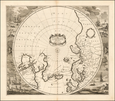
By the seventeenth century, some mapmakers begin to doubt the enormous size of the southern continent, or even its existence at all. In 1639, Henricus Hondius published a map that showed an absence of land at the South Pole. It was surrounded by supposed coast lines, but there was no confident outline of a continent.
Seventy-five years later, in 1714, the theoretical geographer Guillaume Delisle produced a map that showed the routes of navigators that had traveled far south; however, he did not include a southern continent. By the early-eighteenth century, blank space rather than guesswork was preferred by mapmakers, but discussion still raged as to what land lay near the South Pole.
In 1739, Delisle’s son-in-law, Philippe Buache, took Delisle’s 1714 map and added more recent expeditions, most significantly, Lozier de Bouvet’s discovery of Cap de la Circoncision surrounded by icebergs. He also produced another map that included his conjecture as to what a southern land would look like, based on his theory of watersheds that stemmed from the world’s interlocked mountains ranges and river basins. This map shows a two-part southern continent, separated by a nearly landlocked sea. Buache is clear, however, that this is nothing more than an intellectual exercise. Other savants were intrigued by Buache’s ideas. This map, published by the Prussian Academy of Sciences under Leonhard Euler, shows a derivation on Buache’s work as combined with Delisle’s earlier map that extends to the Equator.
The understanding of Antarctica shifted from the hypothetical to the practical with the second voyage of James Cook (1772-1775). In the Resolution, he passed the Antarctic Circle three times, the first ship to do so, drastically limiting the area which could be covered by a southern continent. Mainland Antarctica would only by sighted for the first time on January 27, 1820, by members of the Russian expedition under Bellinghausen.
Euler and cartography
Leonhard Euler (1707-1783) was an extraordinary mathematician and one of the most prolific writers on mathematics of all time. He was the first to recognize sine and cosine as functions, rather than as chords, and was a pioneer of differential equations in calculus, as well as breakthroughs in analytic geometry and number theory. To Euler is attributed the notation f (x) for a function, e for the base of natural logs, i for the square root of -1, π for pi, and many others.
While his work on cartography is less well known, it is a subject with which he engaged throughout his long and productive career. He published several treatises on geodesy, that is the shape of the earth, particularly the shortest routes between points on a curved surface, the calculation of a degree of the meridian, and on the mapping of a spheroid on a flat plane, i.e., projections. Euler led state projects in cartography for the Russian Empire, by whom he was employed for much of his career. Along with Joseph Nicolas Delisle, who tutored him in geography and cartography, Euler prepared a map of the Russian Empire that was published as the Russian Atlas with twenty maps.
While he was the de facto head of the Prussian Academy of Sciences (1759-1766), Euler oversaw the publication of many maps and calendars, which provided income for the Academy. These maps served a general purpose as well as related to specific papers submitted to the institution. This map is an example of the latter. An example of the former, of maps for more general purposes, is the atlas that proved a best-seller for the Academy, Atlas geographicus omnes orbis terrarum regiones. First published in 1753, with maps by the German cartographer Johann Christoph Rode, the school atlas was followed with a second edition in 1760 and a third in 1777.
Leonhard Euler, born on April 15, 1707, in Basel, Switzerland, stands as a towering figure in the history of mathematics and science. His prolific contributions span a wide range of fields including mathematics, physics, astronomy, and engineering. Recognized for his work in areas such as graph theory, topology, mechanics, fluid dynamics, and optics, Euler's influence is immeasurable, making him one of the greatest mathematicians of the 18th century and indeed, in history.
Euler's early life was steeped in academic and religious influence, with his father serving as a pastor and his mother coming from a line of scholars. His intellectual journey began under the guidance of his father and later, under the renowned mathematician Johann Bernoulli at the University of Basel. Despite his initial aspirations in theology, Euler's fascination with mathematics took precedence, leading to a lifelong dedication to the field.
His professional career was marked by significant periods in Saint Petersburg, Russia, and Berlin, Prussia. In Saint Petersburg, under the auspices of the Russian Academy of Sciences, Euler embarked on extensive scientific endeavors, contributing significantly to the academy's prestige. Despite political upheavals and personal challenges, including a near-fatal fever and deteriorating eyesight, Euler's productivity remained unparalleled. His tenure in Berlin, invited by Frederick the Great, was equally fruitful, yielding numerous works and fostering advancements in various disciplines, including map related projects.
Euler's contributions to mathematics are vast and diverse. He popularized and standardized many mathematical notations, such as the concept of a function and the symbols π, e (Euler's number), and i (the imaginary unit). His works in graph theory emerged from practical problems like the Seven Bridges of Königsberg, laying the foundation for this new field of mathematics. Euler also made groundbreaking contributions to the fields of number theory, calculus, and algebra, influencing countless areas of research and application.
In physics and engineering, Euler's insights transformed understanding and methodologies. His formulation of the Euler–Bernoulli beam equation marked a significant advancement in engineering, while his work in fluid dynamics and optics influenced subsequent theories and practices. Euler's contributions extended to astronomy, where his calculations improved celestial navigation and the understanding of cometary orbits.
Euler's personal life was characterized by his devout faith, simplicity, and resilience in the face of adversity. Despite suffering significant loss of eyesight, he continued his mathematical endeavors with the aid of assistants, demonstrating remarkable adaptability and perseverance. His return to Saint Petersburg in his later years saw continued scientific output until his death on September 18, 1783.
Euler's legacy is enduring, with his extensive body of work influencing countless fields and continuing to inspire future generations. His publications, which include more than 800 articles and numerous books, remain critical resources in mathematics and physics. Leonhard Euler's intellectual legacy is a testament to his unparalleled contribution to science and his enduring impact on the advancement of human knowledge.
![[Hunter Island / Tasmania] Carte Trigonometrique des Iles Hunter dressee Par L. Freycinet, Commandant le Casuarina -- December 1802 (Rare Separately Published Example)](https://storage.googleapis.com/raremaps/img/small/53937.jpg)
![[ Western Australia ] Carte de la Terre D'Edels et d'une partie De Celle D'Endracht (a la Nouvelle Hollande) Dressee Par M. L. Freycinet, Commandans la Goelette le Casuarina. (1801 & 1803) (Rare Separately Published Example)](https://storage.googleapis.com/raremaps/img/small/53267.jpg)