|
||

|

|
|

|
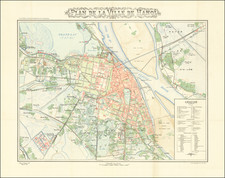
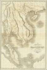
Exceptional large cadastral map of Tay Ninh Province, prepared during a period of French Colonial rule in the region.
A remarkable large format map of the Tay Ninh Province during the French Colonial period, which includes the names of dozens of large land owners whose reserves are named and numbered and shown in green.
The map identifies number of government posts, including Administrative headquarters, telegraph offices, and forest posts occupied by European and Indigenous administrators.
Also noted are rubber plantations, forest reserves, stone roads, dirt roads and other details.
Among the more notable features are the tracts of land reserved to "Lotissement anciens combattants" (which translates as Veterans housing estate).
Tay Ninh Province
As a former Khmer territory, the province is called Raung Damrey. The Vietnamese conquered Raung Damrey in 1770. The territory was occupied early in the 19th century by the Vietnamese under the emperor Gia Long. The Cao Đài religion originated in Tây Ninh. It is the birthplace of Trình Minh Thế, a nationalist and military leader during the end of the First Indochina War.
Because of the once-vaunted political and military power of the Cao Dai, this region was the scene of prolonged and heavy fighting during the First Indochina War. Tây Ninh province served as a major terminus of the Ho Chi Minh trail during the American War, and in 1969 the Viet Cong captured Tây Ninh town and held it for several days.
During the period of conflict between Cambodia and Vietnam in the late 1970s, the Khmer Rouge launched a number of cross-border raids into Tây Ninh province.
Rarity
The map is very rare. We were unable to locate another example.