This item has been sold, but you can enter your email address to be notified if another example becomes available.


|
||

|

|
|

|
Stock# 73204
Description
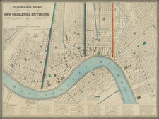
Bellin's important early map of New Orleans, first issued in Xavier Charlevoix's Histoire de la Nouvelle France.
The present example is the second state of the map. The first state is distinguishable from subsequent states by the inclusion of the date, the position of the title of the map and the note in the lower right corner that the map was engraved by Dheulland.
The map includes the earliest obtainable plan of New Orleans, complete with a key naming 18 placenames. The plan names the streets and well over 100 buildings are shown.
A nice example of this important early map of New Orleans.

![[ Tennessee / Louisiana / Mississippi / Alabama ] Boston Mountains (408) Radar AAF Aeronautical Chart](https://storage.googleapis.com/raremaps/img/small/97161.jpg)
![[Florida to New Orleans] The North Coast of the Gulf of Mexico from St. Marks to Galveston . . . 1842](https://storage.googleapis.com/raremaps/img/small/83469.jpg)