The item illustrated and described below is sold, but we
have another example in stock. To view the example which
is currently being offered for sale, click the
"View Details" button below.


|
||

|

|
|

|
Stock# 73190
Description
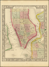
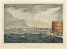
Interesting antique Ensign & Thayer map of Manhattan from the Battery to 32nd Street, with Williamsburg and Brooklyn Heights to the east (bottom).
Inset maps of upper Manhattan and Jersey City are positioned in the upper-left corner of the map.
The map locates three "Fire Alarm" districts, each divided into two sections. Omnibus routes are colored in orange.
The map was popular in the 1840s and was published for a number of years.
Condition Description
Original folder, with gilt title. Original hand-color. Evidence of old folds and some soiling.
Reference
Haskell 867.
![(Viele Water Map) Sanitary & Topographical Map of the City and Island of New York [bound in:] Report of the Council of Hygiene and Public Health of the Citizens Association of New York Upon the Sanitary Condition of the City [and with map:] Sanitary and Social Chart of the Fourth Ward of the City of New York](https://storage.googleapis.com/raremaps/img/small/101301.jpg)
![[Chelsea, New York City] Map of Land in the Twelfth Ward of the City of New York Belonging to the Estate of George C. Schroepel Decd.](https://storage.googleapis.com/raremaps/img/small/59760.jpg)