This item has been sold, but you can enter your email address to be notified if another example becomes available.


|
||

|

|
|

|
Stock# 73178
Description
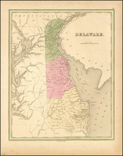
Scott's map of Delaware is one of the earliest obtainable maps of Delaware to appear in an American atlas.
The map is highly detailed and shows towns, rivers, bays, islands, etc.
The map appeared in Scott's The United States Gazetteer: Containing an Authentic Description of the Several States. Their Situation, Extent, Boundaries, Soil, Produce, Climate, Population, Trade and Manufactures. Together with the Extent, Boundaries, and Population of their Respective Counties. Also, an Exact account of the Cities, Towns, Harbours, Rivers, Bays, Lakes, Mountains, &c. Illustrated with Nineteen Maps, Printed in Philadelphia by F. & R. Bailey, at Yorick's Head, No. 116.
Condition Description
Some minor foxing and offsetting. Two horizontal folds. Three spots of dampstain in the left margin. Good or better.
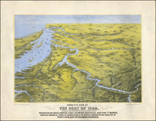
![(U.S. Civil War) Panorama des Kriegsschauplatzes [Bird's-Eye View of the Theater of War Showing Virginia, Maryland, Deleware & Columbia]](https://storage.googleapis.com/raremaps/img/small/99760.jpg)
![Map of the Main Portion of Pittsburg and Allegheny [with verso] Delaware. Maryland.](https://storage.googleapis.com/raremaps/img/small/84993.jpg)