


|
||

|

|
|

|
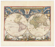
The First World Map To Focus on Science over Allegorical Embellishment.
Spectacular contemporary hand-colored first state of Jean Boisseau's rare double hemisphere map of the World, first issued in Paris in 1636. Dedicated Giustiniano Priandi, the Duke of Mantua's (Carlo Gonzaga) Ambassador to Paris, the map marks an important milestone, the beginning of the transition from the Dutch decorative style of map embellishment to the French style of science over embellishment.
The map is Boisseau's first world map. Based upon the 1630 Henricus Hondius' map of the World, Boisseau has removed the decorative embellishments and replaced them with scientific diagrams and information which was more appropriate for the scientifically minded French market.
Prior to Boisseau, larger world maps were embellished by allegorical scenes. While images of the celestial and polar hemispheres had previously appeared on maps, it was Jean Boisseau's map that was the first to eliminate completely the tradition of allegory and set forth a combination of scientific diagrams and data on a back background, serving as a model which would be followed by other French mapmakers over the next several decades (Tavernier, Berey, Picard, Jollain, and Sanson), but which would not be adopted outside of France until the end of the 17th century.
The map includes two celestial spheres, text panels with geographical and astronomical data, the names of the winds and the heavenly orbits, a circular diagram showing compass points, and a 30-year calendar, beginning in 1637.
This is the first state of the map, which was separately issued and then also bound into Boisseau's rare Theatre Geographique du Royaume du France (1641).
The second state of the map updates the date to 1646.
![[Tracking Noah's Descendants] The Countries of The Ancient World Exhibiting The Probable Settlement of the Descendants of Noah . . .](https://storage.googleapis.com/raremaps/img/small/97933.jpg)
![[ World Powers - Confrontation or Relaxation? ] Weltmachte-Konfrontation oder Entspannung?](https://storage.googleapis.com/raremaps/img/small/90939.jpg)
![[Early Photographic Facsimile of the 1527 Weimar Spanish World Map]](https://storage.googleapis.com/raremaps/img/small/67281.jpg)