|
||

|

|
|

|
The Contentious Search of the Northwest Passage in the 1740s
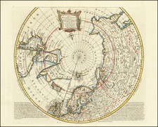
Fine mid-eighteenth-century map of northwestern Hudson’s Bay, emphasizing possible inlets that might lead to the elusive Northwest Passage.
The map was published following the 1746-7 voyage sponsored by the schemer and politician Arthur Dobbs and led by Captains Francis Smith and William Moor, to accompany a book by Theodorus Swaine Drage, who had sailed on the voyage as a clerk.
This is one of three maps engraved by Thomas Jefferys which accompanied Swaine Drage’s The Great Probability of a Northwest Passage: Deduced from Observations on the Letter of Admiral De Fonte, published in London in 1768. The map illustrates the geographic encounters made by Captain Smith, who is mentioned on the map, and Captain Moor in the California and the Dobbs Galley respectively.
Smith was a former HBC employee who was an experienced commander in the waters of Hudson’s Bay. Interestingly, he was joined on the expedition by his wife, Kitty, who became the first white woman to winter in Hudson’s Bay in the eighteenth century.
Meant to explore more fully the reach of Wager Bay and the surrounding area, the ships set out in May 1746. They had a rough crossing and took nearly a month to pass through the Hudson Strait. Their first stop was Marble Island, near James Douglas’s Bay, to measure the tides. They decided to winter at York, where resentment corroded the relationship between the captains and local HBC officials, as well as that between the captains themselves. By the time spring came, the captains were barely on speaking terms.
Their interactions were so poisoned that the men conducted two practically separate expeditions in 1747. They probed Douglas’s Bay, also known as Rankin’s Inlet, to no avail. Farther north, they named and sailed up Chesterfield Inlet, although their results there were inconclusive. Here, the feature bears the note, “The extent of this Inlet is undiscover’d.”
Next, they made their way into Wager Bay, which Dobbs was convinced held the key to the passage. The advance vessel had not gotten far, however, when they found a cataract—marked here as “The Fall”—and two unnavigable rivers. Their hopes had been dashed. The two ships returned home; there was so much scurvy on the California that Smith himself had to take the wheel. They finally made it to the Thames in October 1747 with very little to report beyond the sounding depths, variation readings, wind directions, and outline of Chesterfield Inlet shown here.
Not even these feeble findings could dampen the enthusiasm for a Northwest Passage, as this map featured in Swaine Drage’s work calling for more exploration in 1768.
The search for a Northwest Passage to the eighteenth century
Today, the most famous expeditions in search of the Northwest Passage are those that took place in the mid-nineteenth century, including the ill-fated Franklin voyage. However, finding a passage to Asia via a northern route was a centuries-old endeavor. Indeed, Ptolemy, in the second century CE, suggested that there was a sea route between Europe and East Asia. The expansion of the Ottoman Empire in the fifteenth century led Columbus and De Gama to explore for alternative access to Asian markets to the west and south. The information they brought back led Europeans to look to the northwest and northeast for a shorter, yet treacherous and icy, way to China.
The first recorded search for the Northwest Passage was the voyage of John Cabot in the late fifteenth century, following in the wake of Norse voyages to North America that occurred in the eleventh century. With the support of Bristol merchants, Cabot landed in Newfoundland in 1497. The following year, in a voyage supported by Henry VII, he left with five ships and 200 men; the squadron never returned. In the early sixteenth century, John’s son, Sebastian, led several voyages to what is today Canada.
Early English and French voyages to North America were constantly on the look-out for passages that might lead to the Pacific. For example, Jacques Cartier led an expedition at the behest of Francis I of France. Cartier ranged over the coasts of Newfoundland and the Gulf of St. Lawrence; he was the first European to contact Prince Edward Island, which, alas, was not the Northwest Passage. A second voyage took Cartier to the location of Quebec, which he claimed for France.
The Spanish too sought the Northwest Passage. They originated the toponym of the Strait of Anian, a displacement of a place name from Marco Polo’s writings, which soon caught on with mapmakers across Europe. Conquistador Hernán Cortés funded the voyage of Francisco de Ulloa from Acapulco north in search of the western entrance to the Passage. Ulloa got to the Gulf of California before turning back.
The English did not mount many expeditions during the reign of Henry VIII, who was more focused on the power balance in Europe, but under Elizabeth I many voyages set out to the northwest. Martin Frobisher, a privateer, led three attempts on the Passage in 1576, 1577, and 1578. He thought that he had discovered gold in Frobisher Bay, on Baffin Island, but it turned out to be iron pyrite.
John Davis also led three expeditions north, in 1585, 1586, and 1587. He sailed along Greenland, Baffin Island, and Labrador, as well as charted the Davis Strait. He also found the entrance to Hudson Strait, which would be named for Henry Hudson thirty years later.
John Smith searched for the passage while sailing up Chesapeake Bay in 1608. He did not find it, but he wrote to his friend Hudson that he thought it still might lie just to the north. In the employ of the Dutch East India Company (VOC), Hudson set out in 1609. He first ventured up the Hudson River; while this was again no Northwest Passage, it did help the Dutch to colonize New York, or New Amsterdam as they called the settlement. In 1610, Hudson tried again, this time entering the eponymous Hudson Bay. His ship was trapped in the ice, his crew mutinied, and Hudson, his son, and seven others were set adrift in a small boat, never to be seen again.
One of the mutineers who escaped trial was Robert Bylot, who accompanied Thomas Button on his Arctic voyage in 1612-13. Bylot also accompanied William Baffin to the Arctic in 1615 and 1616; their reports of Baffin Bay were considered fantastic until revisited by John Ross two hundred years later.
Two further explorers, Luke Foxe and Thomas James, went on separate voyages in 1631. Foxe investigated the western shore of Hudson Bay, while James visited the south. These were the last English attempts on the Passage for a century, but the names of Frobisher, Davis, Hudson, Button, Baffin, Foxe, and James are still sprinkled liberally in the high latitudes of the Arctic.
Arthur Dobbs, the HBC, and the search for the Northwest Passage in the mid-eighteenth century
The Hudson’s Bay Company (HBC) was founded in 1670. While they only operated a few outposts at the edge of Hudson’s Bay at this time, the Company enjoyed exclusive trading rights for the entire drainage network of rivers and streams that flowed into the Bay, an enormous swath of land that was little explored by Europeans. However, the Company preferred to focus almost exclusively on trade; exploration was not a priority.
The Company was also notorious for their closed information policy; the less anyone knew about their trading practices and possessions, the better. The HBC’s charter was kept a secret and their employees were expected to stay quiet about how the Company, and especially its Bayside factories, were run. Both the overland expeditions led by William Stuart and Thanadelthur, a Chipewyan woman, in 1715-16, and that of Richard Norton in 1717-18, as well as the ill-fated voyage of James Knight (1719) in search of minerals were kept from the public eye.
The Company’s clandestine policies and privileges did not sit well with others eager to cash in on the supposed riches of the far North. One of the foremost individuals interested in the operation of the Company was Arthur Dobbs, an Irish MP and future Governor of the North Carolina colony.
Dobbs was behind the campaign to find the Northwest Passage in the mid-eighteenth century. His first foray into the subject was in 1731, when he wrote a seventy-page pamphlet on the subject. At first, Dobbs saw the HBC as an ally and possible partner. By 1737 he was soliciting them to fund a voyage in search of the Northwest Passage. The Company expressed polite interest but showed no serious initiative on the matter. Undaunted, Dobbs continued to discuss the possibility of a passage with whichever powerful ear he could access, including First Lord of the Admiralty Sir Charles Wager. Eventually, news of the suggested voyage reached King George II, who expressed interest.
That was enough for the Admiralty to organize a ship to follow Dobbs’ instructions. A former HBC captain and Fellow of the Royal Society, Christopher Middleton, was commissioned in the Royal Navy and given command of the Furnace. He was to proceed to Roe’s Welcome and search for a westward inlet in the area. Middleton and his crew left England in early June 1741; they wintered, supported grudgingly by the HBC, at Churchill in Hudson’s Bay and then headed north in the short sailing season of 1742.
The Furnace limped back to England in October 1742. Practically all of the crew was suffering from scurvy and Middleton had to leave some of his men to recuperate in the Orkney Islands. Although he had made some useful observations on temperature, latitude and longitude, and magnetic variation, Middleton reported that he had found no Northwest Passage. The most promising moment had been the encounter with an inlet Middleton named for Wager; upon sailing up it, however, he found it to be a river, not a passage.
Dobbs begged to differ. He examined Middleton’s journal and decided the river was actually an inlet and that Middleton had failed to explore far enough up its extent. The men also disagreed about the existence of what Middleton called Frozen Strait to the northwest of Roe’s Welcome. For years, the presence of large whales and roaring tides in the far western part of the Bay had surprised navigators and suggested, to some at least, that there must be a connective passage to the Pacific Ocean from the west. Middleton explained the whales and the tides as coming in via the Frozen Strait, which was impassable to ships due to ice. Dobbs denied that the strait existed at all. The men’s disagreements spiraled out of control from private letters to published works; they wrote eight books and pamphlets over two years arguing over the geography of the area.
Amidst this paper war, Dobbs wrote a more general work that attacked the HBC and gave the reading public one of its first glimpses, however problematic and erroneous, of Hudson’s Bay. His Account of the Countries adjoining to Hudson’s Bay (1744) included a map by Joseph La France, a coureur de bois who had traveled widely in the interior of North America. La France told of native peoples from near Hudson’s Bay who had journeyed all the way to the Pacific Ocean.
While such a trip is not unlikely, the way it was told by La France to Dobbs (or just as told by Dobbs) was fantastical; however, it further stoked the interests of those who wished to find a quick passage to the ports of Asia. In 1745, Parliament approved a prize of £20,000 to anyone who would find a Northwest Passage. In conjunction with the prize, a group of merchants formed the North West Committee; these are the names listed in the title of the map. The committee offered a subscription to raise money for a voyage—the Admiralty was not interested in supporting another venture after Middleton’s. This group outfitted two ships, the Dobbs Galley and the California. A late addition to the crew of the former was Henry Ellis; Ellis was a skilled draughtsman and a mineralogist, but he was placed on board primarily as agent for the North West Committee.
The ships left England in May of 1746. They returned in October of the following year having named and probed the Chesterfield Inlet, as well as sailed further up Wager’s Bay, River, or Inlet (depending on one’s opinion of the probability of a passage there). Although the experiences of the crews had been dismal, and their results meager, Dobbs was able to turn metaphorical lemons into lemonade (if only the crews had some actual lemons, as they suffered terribly from scurvy, just like Middleton’s).
Ellis’ account should be considered in the context of the larger campaign waged by Dobbs against the HBC’s monopoly. Dobbs and his supporters laid the blame of the most recent failed voyage at the feet of the HBC. At the same time, crew members were wary of becoming the focus of Dobbs’ ire; they wished to avoid what Middleton had endured and what the Company was now facing.
Ellis wasted no time in publishing his account of the voyage, which appeared in August 1748. Part of his hurry was competition; a rival account, by Theodore Swaine Drage, who is associated with this map and who sailed in the California, was also being prepared. A Dublin edition of Ellis' work followed in 1749, along with Dutch and French translations. The book laid out the events of the voyage as Ellis had seen them; it also was a propaganda piece arguing for the continued existence of a passage, if only more voyages would be sent. Indeed, part of the book’s long title explains that it offers, “A fair View of the Facts and Arguments from which the future finding of such a Passage is rendered probable.” Specifically, Ellis suggested that the strait most likely was part of Chesterfield Inlet or attached to what Middleton called Repulse Bay to the north.
Although the Northwest Passage was never discovered in either of those places, Dobbs was successful in his attempt to tarnish the reputation of the HBC. The 1746-7 voyage triggered a Parliamentary Inquiry. Witnesses testified that the Company had ignored its duty to search for a Northwest Passage, putting the Company on the defensive. While Parliament ultimately decided to preserve the HBC’s monopoly, their isolation was shattered.
In 1752, the first book by a former employee was published. Account of Six Years Residence in Hudson’s-Bay, by Joseph Robson, criticized the practices and forts of the HBC. A disgruntled employee who was fired in 1747, Robson likely wrote some of the work. He also testified against the Company as a witness before the Parliamentary Committee. The rest of the book was by none other than Dobbs himself, who continued to believe in a Northwest Passage until his death in 1765.
The exploration dreams and schemes of Drage
The search continued after Dobbs’ death, of course. When the British Admiralty began exploring the Pacific in earnest after the end of the Seven Years’ War, geographers advocated for their favorite geographic chimeras, including the discovery of a southern continent and of the Northwest Passage. This map was featured in a book by none other than Theodorus Swaine Drage, also known as Charles Swaine, of the California.
On the voyage, Swaine was known as Drage, who seems to have been born in ca. 1712. He wrote of his experiences as a clerk on the California, publishing a two-volume work in May 1748 and February 1749, respectively. Then, he disappears from the records for a decade.
However, a Captain Charles Swaine appeared in the British colonies in North America in 1750, claiming to be the clerk of the California and advocating for a Northwest Passage expedition. One of his subscribers was Benjamin Franklin. Swaine sailed in the Argo in 1753, but he failed to even pass Hudson Strait. He tried again the following year, but with no luck.
Swaine went on to serve as General Braddock’s commissary in 1754 and as a politician in Pennsylvania. In his marriage record to Hannah Boyte we get the first glimpse of his names together, as Charles Swaine Drage. In 1768, he published the work in which this map featured as Theodorus Swaine Drage. In a final twist, Drage was ordained and served as an Anglican clergyman in North Carolina, where he died in 1774.
Rarity
The map is extremely rare. The complete book appears infrequently on the market, with 2 appearances at auction in the past 10 years.
![[ Charleston, Boston, New York, St. Augustine, Bahamas, etc ] Particular Draughts of some of the Principal Towns and Harbours belonging to the English French and Spanish in America and the West Indies.](https://storage.googleapis.com/raremaps/img/small/102804.jpg)

![[Unique Extra-Illustrated Example!] Carte Nouvelle Contenant La Partie d'Amerique La Plus Septentrionale, . . . Le Canada ou Nouvelle France, La Nouvelle Ecosse, La Nouvelle Angleterre, Les Nouveau Pais Bas, La Pensylvanie . . . Et Jle. de Terre Neuve . . .](https://storage.googleapis.com/raremaps/img/small/47720.jpg)