


|
||

|

|
|

|
Scarce First State
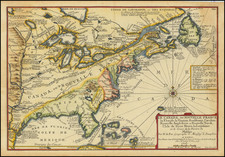
Antique 18th century map of the Eastern United States and Canada, from De Fer's Atlas Curieux.
De Fer's map illustrates the extent of French royal control over the North American Continent. Canada, also named Nouvelle France on the map, extends from north of Labrador to south of the Tropic of Cancer. The various English colonies are reduced in size, shown as all but limited to the Atlantic Coast.
This is undoubtedly a political statement in a map printed with blessings from the King of France. The Mississippi flows due South in this example, originating north of Lake Superior and outflowing in eastern Texas. The tributaries of the Mississippi are described and annotated, most notably the Ohio ou Bell Riviere, which starts far south of its true origins and the Oubache River.
Includes boats on early explorations, forts, rivers and Indian Tribes abound in this marvelous work.
Nicholas de Fer (1646-1720) was the son of a map seller, Antoine de Fer, and grew to be one of the most well-known mapmakers in France in the seventeenth century. He was apprenticed at twelve years old to Louis Spirinx, an engraver. When his father died in 1673, Nicholas helped his mother run the business until 1687, when he became the sole proprietor.
His earliest known work is a map of the Canal of Languedoc in 1669, while some of his earliest engravings are in the revised edition of Methode pour Apprendre Facilement la Geographie (1685). In 1697, he published his first world atlas. Perhaps his most famous map is his wall map of America, published in 1698, with its celebrated beaver scene (engraved by Hendrick van Loon, designed by Nicolas Guerard). After his death in 1720, the business passed to his sons-in-law, Guillaume Danet and Jacques-Francois Benard.

![Louisiana [Large-Paper Example]](https://storage.googleapis.com/raremaps/img/small/83278.jpg)
![[Signed Political Satire Artwork] Vietnam ... Vietnam ... Vietnam ...](https://storage.googleapis.com/raremaps/img/small/68726.jpg)