|
||

|

|
|

|
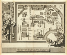
Finely colored example of Braun & Hogenberg's view of Ostia, the harbor of Rome, as it appeared during the Roman Empire.
Fabulously detailed and elegantly engraved, the map captures the grandeur of the harbor, which was built under the emperor's Trajan and Claudius.
The Roman Harbor of Ostia
The map extends from the mouths of the Tevere (Tiber) River and the Fiumicino River. The map shows both the original Harbor of Ostia, which dates to at least the 4th Century BC and which was created at the time of Emperor Claudius (Porto Claudio Ostiense on the map), as well as the later harbor constructed under the directions of the Emperor Trajan (Porto Traiano on the map).
The harbor of Ostia was the primary harbor for the ancient city of Rome. Ostia may have been Rome's first colonia. According to the legend Ancus Marcius, the semi-legendary fourth king of Rome, first destroyed Ficana, an ancient town that was only 11 miles from Rome, which had a small harbor on the Tiber. Following the destruction of Ficana, he directed the establishment of a new colony 6 miles further west and closer to the sea coast. An inscription seems to confirm the establishment of the old castrum of Ostia in the 7th century BC. The oldest archaeological remains so far discovered date back to only the 4th century BC. In 68 BC, the town was sacked by pirates. During the sack, the port was set on fire, the consular war fleet was destroyed, and two prominent senators were kidnapped. This attack caused such panic in Rome that Pompeii the Great arranged for the tribune Aulus Gabinius to rise in the Roman Forum and propose a law, the Lex Gabinia, to allow Pompeii to raise an army and destroy the pirates. Within a year, the pirates had been defeated. The town was then re-built, and provided with protective walls by the Marcus Tullius Cicero.
Ostia was expanded during the first century AD under the influence of Tiberius, who ordered the building of the town's first Forum. The town was also soon enriched by the construction of a new harbor on the northern mouths of the Tiber. The new harbor was excavated from the ground at the orders of the emperor Claudius. This harbor became silted up and needed to be supplemented later by a harbor built by Trajan and finished in the year AD 113; it has a hexagonal form, in order to reduce the erosive forces of the waves. This took business away from Ostia itself (further down river) and began its commercial decline.
At its height, Ostia includes a famous lighthouse and the Ostia Synagogue, the earliest synagogue yet identified in Europe. In addition, Ostia had a large theatre, many public baths, numerous taverns and inns, and a firefighting service. Trajan also directed a widening of the naval areas, and ordered the building of another harbor, again pointing towards the north.
Ostia grew to 50,000 inhabitants in the 2nd century, reaching a peak of some 100,000 inhabitants in the 2nd and 3rd centuries AD. Ostia became an episcopal seen as early as the 3rd century, the cathedral (titulus) of Santa Aurea being located on the burial site of St. Monica, mother of Augustine; she died in an inn in the town. In time, naval activities became focused on Portus instead. A slow decline began in the late Roman era around the time of Constantine I, with the town ceasing to be an active port and instead becoming a popular country retreat for rich aristocrats from Rome itself. The decaying conditions of the city were mentioned by St. Augustine, when he passed there in the late 4th century.
With the end of the Roman Empire, Ostia fell slowly into decay, and was finally abandoned in the 9th century due to the repeated invasions and sackings by Arab pirates, including the Battle of Ostia, a naval battle in 849 between Christian and Saracens; the remaining inhabitants moved to Gregoriopolis.
Georg Braun (1541-1622) was born and died in Cologne. His primary vocation was as Catholic cleric; he spent thirty-seven years as canon and dean at the church St. Maria ad Gradus, in Cologne. Braun was the chief editor of the Civitates orbis terrarum, the greatest book of town views ever published. His job entailed hiring artists, acquiring source material for the maps and views, and writing the text. In this role, he was assisted by Abraham Ortelius. Braun lived into his 80s, and he was the only member of the original team to witness the publication of the sixth volume in 1617.
Frans Hogenberg (ca. 1540-ca. 1590) was a Flemish and German engraver and mapmaker who also painted. He was born in Mechelen, south of Antwerp, the son of wood engraver and etcher Nicolas Hogenberg. Together with his father, brother (Remigius), uncle, and cousins, Frans was one member of a prominent artistic family in the Netherlands.
During the 1550s, Frans worked in Antwerp with the famous mapmaker Abraham Ortelius. There, he engraved the maps for Ortelius’ groundbreaking first atlas, published in Antwerp in 1570, along with Johannes van Deotecum and Ambrosius and Ferdinand Arsenius. It is suspected he engraved the title page as well. Later, Ortelius supported Hogenberg with information for a different project, the Civitates orbis terrarium (edited by Georg Braun, engraved by Hogenberg, published in six volumes, Cologne, 1572-1617). Hogenberg engraved the majority of the work’s 546 prospects and views.
It is possible that Frans spent some time in England while fleeing from religious persecution, but he was living and working in Cologne by 1580. That is the city where he died around 1590. In addition to his maps, he is known for his historical allegories and portraits. His brother, Remigius, also went on to some fame as an engraver, and he died around the same time as his brother.
![[ Ostia - Old Port of Rome ] Utriusque Portus Ostia Delineatio -- Amplis Prudentis Domino Cornelio Witzen Urbis Amsteledamensis Consuli ac Senatori, Nuper in fupremo rei maritime Concilio ibidem Delegato, Tabula hane D.D. J. Blacu](https://storage.googleapis.com/raremaps/img/small/102613.jpg)
![[A Celebration of the 12 Caesars in A Roman Triumphal Procession] Ornatissimi Triumphi, uti L: Paullus de Rege Macedonum Perse capto, P. Africanus Aemilianus de Carthaginiensibus excisis; Cn: Pompejus Magnus ex oriente, Vespasianus, Trajanus, et alii Imperatores Romani Triumpharunt: ex vetustis lapidum, nummorum et Librorum monumentis accuratissima discriptio, Onuphrii Panvinii Veronensis inventoris Opera et aeneis formis Venetiis Ao. salutis MD. LXXX Greo: XIII](https://storage.googleapis.com/raremaps/img/small/89536.jpg)