


|
||

|

|
|

|
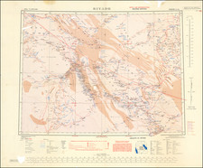
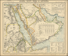
Detailed map of the Middle East, published in London by Letts, Son & Co.
The present map of the region includes significant detail not available on earlier maps of the region, including illustration of the earliest telegraph lines in the region.
The peninsula is now criss-crossed with roads and details on settlements and regional tribal information, with Riad (Riyadh) and a number of other towns located, the largest of which are underlined in blue.
Katar (Qatar) is shown, with the towns of Bidah (Doha) and Owhali noted.
Further south, in the modern region of the United Arab Emirates, Abouthubi (Abu Dhabi), Sharja and Deba (Dubai) are named, as is Ras-el Khyma (Ras Al-Kalmah), the later identified as a Pirate Port. The 20 villages of Beldan Beni Shab are also prominently named.
In Oman, there are a number of early roads and towns located, along with a note referencing Wellsted's Tracks and "Sandy plains with dwarf Acaicas brackish wells and Arab Camps).
At the center of the map is a note regarding the domestic production and imports for the region, along with populations and agricultural information.
![[Portrait] L'Asie.](https://storage.googleapis.com/raremaps/img/small/79746.jpg)