|
||

|

|
|

|
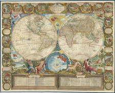
A striking example of this scarce 17th Century English Map of the World, based upon the earlier map of Willem Blaeu by Pieter Van Den Keere.
Englishman Moses Pitt, with the heirs of Jan Jansson, commenced publication of what they hoped would be the largest Atlas every published surpassing in size the atlases of Blaeu and Jansson published in the mid-17th Century. Unfortunately, only four of the planned twelve volumes were completed, before Moses Pitt landed in debtor's prison and the project was scuttled. While the atlas project was a failure, a number of the maps, including Pitt's original map of the North Pole and this map, have become decorative and sought after in the collector's market.
The map retains the decorative borders of the original edition, but has cartography updated to show California as an island, a reduction of the Great Southern Continent and an indication of the emerging Nova Hollandia (Australia) continent. The panels surrounding the map show images of the sun, moon and planets as gods--Luna, Mercury, Venus, Sol, Mars, Jupiter and Saturnus; representations of fire air, water and earth in human form; representations of the seasons--spring, summer, autumn and winter--as humans; and the 7 wonders of the ancient world. One of the most striking and highly sought after of all world maps.
The popular misconception of California as an island can be found on European maps from the sixteenth through the eighteenth centuries. From its first portrayal on a printed map by Diego Gutiérrez, in 1562, California was shown as part of North America by mapmakers, including Gerardus Mercator and Abraham Ortelius. In the 1620s, however, it began to appear as an island in several sources. While most of these show the equivalent of the modern state of California separated from the continent, others, like a manuscript chart by Joao Teixeira Albernaz I (ca. 1632) now in the collection of the National Library of Brasil shows the entire western half of North Americas as an island.
The myth of California as an island was most likely the result of the travel account of Sebastian Vizcaino, who had been sent north up the shore of California in 1602. A Carmelite friar, Fray Antonio de la Ascensión, accompanied him. Ascension described the land as an island and around 1620 sketched maps to that effect. Normally, this information would have been reviewed and locked in the Spanish repository, the Casa de la Contratación. However, the manuscript maps were intercepted in the Atlantic by the Dutch, who took them to Amsterdam where they began to circulate. Ascensión also published descriptions of the insular geography in Juan Torquemada’s Monarquia Indiana (1613) (with the island details curtailed somewhat) and in his own Relación breve of ca. 1620.
The first known maps to show California as an island were on the title pages of Antonio de Herrera’s Descripción de las Indias Occidentales (1622) and Jacob le Maire's Spieghel Der Australische Navigatie (1622). Two early examples of larger maps are those by Abraham Goos (1624) and another by Henry Briggs, which was included in Samuel Purchas’ Hakluytus Posthumus or Purchas his Pilgrimes (1625). In addition to Briggs and Goos, prominent practitioners like Jan Jansson and Nicolas Sanson adopted the new island and the practice became commonplace. John Speed’s map (1626-7), based on Briggs’ work, is well known for being one of the first to depict an insular California.
The island of California became a fixture on mid- and late-seventeenth century maps. The island suggested possible links to the Northwest Passage, with rivers in the North American interior supposedly connecting to the sea between California and the mainland. Furthermore, Francis Drake had landed in northern California on his circumnavigation (1577-80) and an insular California suggested that Spanish power in the area could be questioned.
Not everyone was convinced, however. Father Eusebio Kino, after extensive travels in what is now California, Arizona, and northern Mexico concluded that the island was actually a peninsula and published a map refuting the claim (Paris, 1705). Another skeptic was Guillaume De L’Isle. In 1700, De L’Isle discussed “whether California is an Island or a part of the continent” with J. D. Cassini; the letter was published in 1715. After reviewing all the literature available to him in Paris, De L’Isle concluded that the evidence supporting an insular California was not trustworthy. He also cited more recent explorations by the Jesuits (including Kino) that disproved the island theory. Later, in his map of 1722 (Carte d’Amerique dressee pour l’usage du Roy), De L’Isle would abandon the island theory entirely.
Despite Kino’s and De L’Isle’s work, California as an island remained common on maps until the mid-eighteenth century. De L’Isle’s son-in-law, Philippe Buache, for example, remained an adherent of the island depiction for some time. Another believer was Herman Moll, who reported that California was unequivocally an island, for he had had sailors in his offices that claimed to have circumnavigated it. In the face of such skepticism, the King of Spain, Ferdinand VII, had to issue a decree in 1747 proclaiming California to be a peninsula connected to North America; the geographic chimera, no matter how appealing, was not to be suffered any longer, although a few final maps were printed with the lingering island.
Pitt was from Cornwall, where he was baptized at St. Teath in 1639. He was educated locally but moved to London when apprenticed to bookseller Robert Littlebury. At the end of his apprenticeship, in 1661, he was made free of the Haberdasher’s Company. His first books to be published with his own imprint appeared in 1667.
Pitt specialized in learned publications and imported scholarly works from continental Europe. He also published the writings of members of the newly formed Royal Society, including Robert Boyle, as well as high-ranking clergymen. In 1678, Pitt was the first bookseller to offer his wares via an auction.
Thanks in part to his ties to the Royal Society, Pitt announced in 1678 that he would publish a massive twelve-volume atlas of the world. The plates were to be based on Dutch maps, with a text written by Bishop William Nicholson and Richard Peers. However, only four volumes ever appeared.
Pitt, who was also managing several properties in Westminster and had expanded in a partnership to Oxford, was spread too thin. The cost of each volume of the atlas alone Pitt estimated at £1,000. One by one, his ventures turned foul, landing him in debtors’ prison for seven years. He died in London, but not in prison, in 1697.

![Western Hemisphere [and] Eastern Hemisphere](https://storage.googleapis.com/raremaps/img/small/77454.jpg)
![A New Map of North America Shewing its Principal Divisions, Chief Cities, Townes, Rivers, Mountains &c. Dedicated to His Highness William Duke of Gloucester [California as an Island]](https://storage.googleapis.com/raremaps/img/small/100578.jpg)