This item has been sold, but you can enter your email address to be notified if another example becomes available.


|
||

|

|
|

|
Stock# 72982
Description
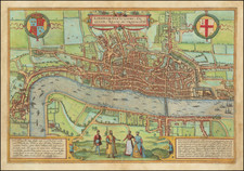
Fine example of Richard Blome's scarce map of London, first published in 1667.
Fine map of London prior to the fire, extending from Westminster to Stepney and from St George's Fields in South to fields Nort of the City. The map is decorated with 16 coats of arms.
Engraved by Wenceslas Hollar for the publisher Richard Blome. From Richard Blome's Geographical Description of the Kingdoms of England, Scotland, and Ireland with the Isles and Territories thereto belonging.
This edition includes a key locating 57 places on the map.
This example is printed on laid paper, circa middle of the 18th century, probably by Sayer or one of the other owners of the plate.
![Regionis, quae est circa Londinum specialis repraesentatio geographica, ex autographo majori Londinensi . . . 1741 [Includes Bird's-eye View of London and Westminster]](https://storage.googleapis.com/raremaps/img/small/95041.jpg)