|
||

|

|
|

|
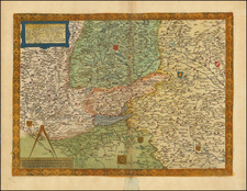
The Duchy of Bavaria -- Centered on The Danube, Inn and Iser Rivers
Exceptional old color example of Jaillot's map of the Duchy of Bavaria and environs, published by Jaillot in Paris.
Munich, Regensburg, Landshut, Freising, Insgolstat, Passau, Hall, Innsbruck are all shown.
The map extends west to Augsburg and the Lech River and South to the Tyrol.
Alexis-Hubert Jaillot (ca. 1632-1712) was one of the most important French cartographers of the seventeenth century. Jaillot traveled to Paris with his brother, Simon, in 1657, hoping to take advantage of Louis XIV's call to the artists and scientists of France to settle and work in Paris. Originally a sculptor, he married the daughter of Nicholas Berey, Jeanne Berey, in 1664, and went into partnership with Nicholas Sanson's sons. Beginning in 1669, he re-engraved and often enlarged many of Sanson's maps, filling in the gap left by the destruction of the Blaeu's printing establishment in 1672.