This item has been sold, but you can enter your email address to be notified if another example becomes available.


|
||

|

|
|

|
Stock# 72963
Description
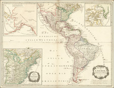
Scarce promotional map of the west coast routes served by the Pacific Steamship Company, the oldest and largest of the commercial carriers operating on the west coast of North America, dating back to the 1840s.
The map illustrates the primary commercial routes of the company, from Alaska to Cabo San Lucas and Mazatlan, with smaller maps showing routes around Los Angeles, The central coast, San Francisco Bay, Eureka and Puget Sound.
The company routes are shown linked with major railroad lines.
Rarity
While maps of the Pacific Steamship Company prior to 1900 are relatively common, we note only 1 map in OCLC between 1900 and 1920 with a similar title.
![[Orange County Ranchos -- Signed by Orange County Surveyor]](https://storage.googleapis.com/raremaps/img/small/92333.jpg)
![(Southern California) Utazás Kalifornia Déli Részeiben [Travel in Southern California] [with map:] Kalifornia déli részei Legújabb kútfök után szerkesztette es rajzolta. [Southern parts of California Edited and drawn after the latest sources.]](https://storage.googleapis.com/raremaps/img/small/92022.jpg)
![[ Hungarian Traveler In the California and the West with a Comanche and Wichita to Hungarian vocabulary ] Levelei Éjszakamerikából -- Tizenkét eredeti rajzok után készült kő- és egynéhány fametszettel. Közli Prépost István (Letters from North America)](https://storage.googleapis.com/raremaps/img/small/98502.jpg)