


|
||

|

|
|

|
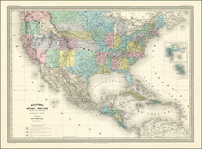
Attractive large format map of the US & Mexico on the eve of the Civil War. Includes marvelous ephemeral western territorial borders, including several fictional territories. California is oddly shaped, extending to the Colorado border. Arizona is now west of New Mexico, but also oddly configured. Washington Terr. extends to the Rocky Mountains, with the southern half of Idaho called Shoshone. Idaho Territory is shown running from within the Shoshone region to the Missouri River, taking up much of what would become Wyoming. Montana Territory is named. Nebraska Territory extends from the Rockie to the Missouri. Texas is oddly configured. The map shows the various Danish, Spanish, French, British, Dutch and Swedish possessions in the Caribbean. Excellent detail throughout, including towns, roads, rivers, mountains, lakes, islands, bays, shoals, points, gulfs, Indian Tribes, Forts, mining regions, etc. The early French, German and Mainzer Colonies in Texas are shown. An excellent large format map. Minor stain in the lower right margin, just entering the image, else a very nice example.

![[All The Way With LBJ - 1964 Presidential Election Campaign Poster] Johnson Humphrey for the USA](https://storage.googleapis.com/raremaps/img/small/88907.jpg)

![The Travellers Guide or Map of The Roads, Canals & Rail Roads of the United States, With the distances from Place to Place By H.S. Tanner 1845 [with] The American Traveller, or Tourists' and Emigrants' Guide Through The United States . . . .](https://storage.googleapis.com/raremaps/img/small/99038.jpg)