This item has been sold, but you can enter your email address to be notified if another example becomes available.


|
||

|

|
|

|
Stock# 72931
Description
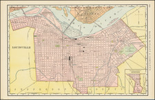
Scarce large map of Louisville on the Ohio River, published by E.J. Coleman & Company in 1943.
Includes an inset map of the business district, locating over 40 points of interest.
The map provides a detailed image of Louisville at the end of World War II, with various public places colored. Nice detail on the transit lines and street cars.
Churchill Downs appears on the map, first constructed in 1875.